
Explore Tolland, CT
Tolland at a Glance
Part of Tolland County
If you’re looking for the best hiking trails in Tolland this is the complete guide to all the long trails, disc golf, and history it has to offer.
Tolland protects over 4,200 acres of open space, which hosts:
- 25 hiking areas for 45 miles of trails
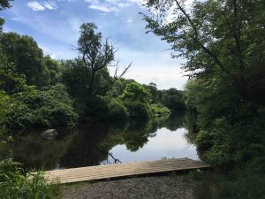
- 3 boating/fishing areas
- 1 disc golf course
- 1 archery course
My Highlights
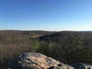
- The overlook at Campbell’s Peaceful Valley
- The archery course at Nye-Holman
Hiking
Town Parks
- Auperin Conservation Area –★★– <1 mile – A short hillside trail that connects to Weigold and the Tobiassen Forest
- Baxter Street Conservation Area –★– 0.3 miles – Old woods road out and back
- Becker Conservation Area –★★– 1 mile – The current terminus of the Willimantic River Trail on this short loop
- Campbell’s Peaceful Valley –★– 2.2 miles – A great rocky overlook with plenty of trails to explore and a connection to Stoppleworth
- Crandall Park –★★★– 5 miles – Popular town park with hiking and mountain biking trails, a beach, courts, fields, pavilions, and more
- Cross Farms –★★– 1 mile – There is an seldom used hiking trail here though half has been taken over by the disc golf course
- Crystal Peat Conservation Area –★★– 1.15 miles – Short trails around the ruins of the Crystal Peat Humus Company
- Heron Cove –★★– <1 mile – Mainly a boat launch into the Willimantic River, but there is a short loop trail that follows the banks
- King Riverside –★★– 1.2 miles – Part of the Willimantic River hiking trail with the remains of Peck’s Mill and the the District IV schoolhouse
- Knofla Conservation Area –★★– 2.9 miles – Forested trails lead down to Knofla’s Pond, a bog view, and hilly loops
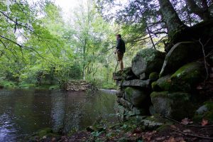
- Luce Conservation Area –★★– 1 mile – Tiny cascades on Charter Brook, a rocky spine covered in young pines, and a flooded stonewall
- Nedweid Conservation Area –★– 1 mile – Seldom used section of the Willimantic River hiking trail connects to King Riverside
- Palmer Kendall Mountain –★★★– 1.5 miles – A ridge overlook, the “knob”, and a rock jumble they call a “quarry”
- Parciak Conservation Area –★★– 2.8 miles – A “meteor” and a quartz boulder highlight the trails here
- Paulk Hill Conservation Area –★★– 5 miles – Mountain bike specific trails that connect to Crandall Park
- River Park –★★– 1 mile – Oddly there are no river views from the park, but trails connect to the Becker CA which do
- Schindler/Schmidt Conservation Area –★★★– 3.8 miles – Mostly easy walking on old roads through rocky terrain
- Shafran Conservation Area –★★– 1.4 miles – One of the most peaceful places with pines, ferns, and clear streams
- Stoppleworth Conservation Area –★– 1 mile – An old cellar hole, birch lined paths, and a connection to Campbell’s Peaceful Valley
- Wanat Park –★★– 0.15 miles – Park geared towards seniors with a labyrinth, ADA trail to an old silo, and open fields
- Weigold Conservation Area –★★– <1 mile – A short trail that connects to Auperin and the Tobiassen Forest
Land Trusts
- Joshua’s Trust
- Madeline Regan Preserve –★★– 1 mile – A figure eight hiking loop preserving a section of the Old Connecticut Path and a dramatic esker
- Tobiassen Forest –★★– 2 miles – A short wooded loop with some grand old trees
- Joshua’s Trust
State Parks / Forest
- Charter Marsh Wildlife Sanctuary – No public access
- Nye-Holman State Forest –★★– <1 mile – One short rough trail, more popular for boating/fishing on the river and its archery course
- Kollar Wildlife Management Area –★★– 5 miles – The remains of Scripture bridge and a range of unblazed trails run through the property
Blue Blaze
- Shenipsit Trail
- Shenipsit Lake –★★– 1 mile – The Connecticut Water Co. trolley trail, flat easy walking with a view or two of the lake
- Shenipsit Trail
The Rest
- Benton Homestead –★– <1 mile – A short unmaintained loop next to the roar of I-84, the homestead is a museum
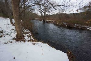
- Willimantic River Trail – Tolland is the current northern terminus of this long trail
Named May, 1715; incorporated May, 1722, from Tolland in Somersetshire, whence Henry Wolcott, grandfather of Gov. Roger Wolcott, chief owner.
{{label}}: {{displayValue}}
{{displayValue}}
{{displayValue}}
{{locationDetails}}
Browse sub-categories
Showing 1 result
Showing {{ showing }} out of {{ foundPosts }} results
