
Shenipsit
Trail Guide
Hike the Shenipsit Trail
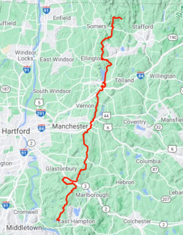
Traveling 50.2 miles from Portland to Stafford this blue blaze trail is maintained by volunteers coordinated by the Connecticut Forest and Park Association.
I thru-hiked the trail in June 2023 over the course of two days during peak mountain laurel bloom. Starting from the southern terminus at Great Hill I hiked 25.7 miles north to the Bolton Park and Ride which took me just over 10 hours. I returned the next morning to continue the hike traveling 24.5 miles to the northern terminus on Greaves Road which took me just under 10 hours.
The trail starts with a bang at the Great Hill overlook of the Connecticut River, passes old mines touching on the history of central Connecticut, through the woods of the Connecticut’s oldest state forest before clambering around Route 2. There are miles of trails on old forest roads rutted by dirt bikes contrasted by miles of trails surrounded by beautiful mountain laurel. There are a handful of road walks and some sections that just exist to connect the trail. In the rugged northern stretches are deep fern forests, a tower overlook from the summit of 1075 ft Soapstone Mountain, and many hills before the trail whimpers to its current end short of the Massachusetts border on Greaves Road.
The name Shenipsit is a Native American word for ‘at the great pool’ which is attributed to Shenipsit Lake
The Shenipsit Striders hold an Annual End to End Run usually in the Fall each year. The fastest known time for running the Shenipsit Trail as of 2023 was set by Justin Kousky in September 2020 with a time of 8h 19m 21s.

Highlights
Links
- CFPA Shenipsit Official Link
- Shenipsit Striders Official Page
- CTMQ – Shenipsit Trail Intro (2010)
- The Air Land and Sea – Shenipsit Trail Guide (2020)
Section List
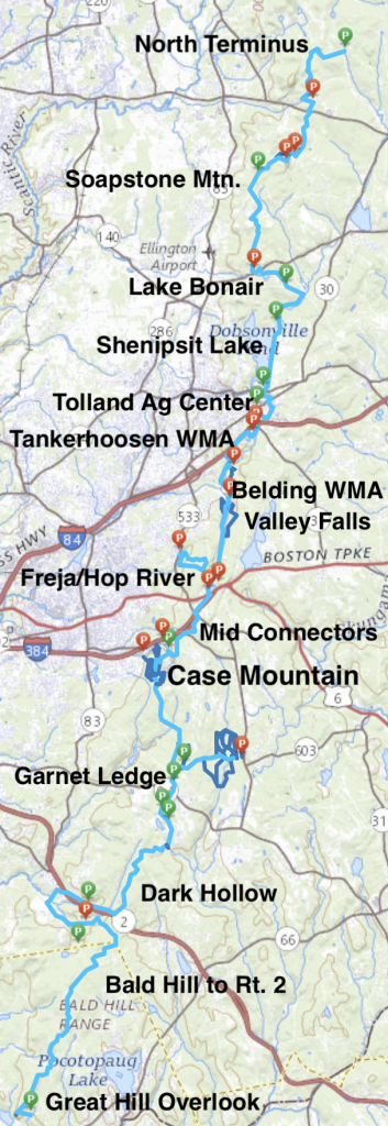
- Parking on Greaves Road
- North Terminus – ★★★- 3.2 miles – Dense hilly section that currently ends with a 0.2 mile road walk on Greaves Road
- Parking on Avery Road
- 0.8 mile road walk on Sodom Rd/Rt-190/Galbraith Rd
- Parking off Gulf Road
- Shenipsit State Forest – 6.1 miles total
- Sodom Road Parcel –★★– 1.0 mile – A little rocky and a little hilly uneventful stretch of trail behind the Somers Sportsman Club
- 0.1 mile road walk on Sodom Road
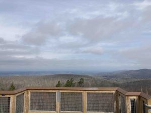
- Soapstone Mountain –★★★– 2.7 miles – Steep climb up to a fantastic view from the tower at the summit
- South Parcel –★★– 2.4 miles – Old forest roads, rutted by off-road vehicles that finally switches to narrow trail
- Parking on Hopkins Road
- 0.2 mile road walk on Rt 140/Hopkins Rd
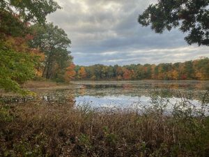
- Lake Bonair –★★– 1.2 miles – Dense fern filled hike with brief views of the pond
- 2 mile road walk Shenipsit Lake Rd to Grahaber Rd
- Parking on Grahaber Road
- Shenipsit Lake –★★– 1.8 miles – A flat easy walk along an old rail bed with occasional views of the water
- Parking on Route 74
- 1.2 mile road walk along Gerber Dr/Kingsbury Ave/Rt. 74
- Tolland Agricultural Center –★★– 0.6 miles – To the back corner of the property, past a pollinator garden and small pond
- Parking at Tolland Ag Center lot
- 1.0 mile road walk along Reservoir Rd to Rt. 30 to pass under I-84
- Connection to Walker’s Reservoir
- Parking off Reservoir Road
- Tankerhoosen WMA –★★– 1.5 miles – A bit pinched along noisy I-84 to curl around a small reservoir
- Belding WMA –★★– 1.6 miles – Peaceful pines along the banks of the Tankerhoosen River
- Parking at Valley Falls lot
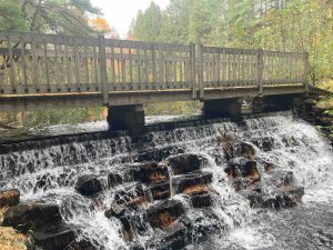
- Valley Falls –★★★– 0.2 miles – Descend from the Hop River Trail to the western edge of Valley Falls Pond
- Hop River Trail –★★– 2.2 miles – Flat stretch popular with cyclists with some railroad history
- Freja Park –★★– 0.6 miles – 0.6 miles past the old Manchester Drive-In along Bolton Notch Pond and onto the
- Parking at the Bolton Park & Ride
- East Coast Greenway –★★– 0.9 miles – Nice new paved section along I-384, nice for cyclists, not as great for hikers
- Shenipsit Mid-Connectors –★★– 2 miles – Four short awkward less-traveled sections amid private property
- Parking off Birch Mountain Road
- Case Mountain –★★★★★– 1.9 miles – While Case Mtn is very popular the Shenipsit Trail through the park is quiet and beautiful
- Garnet Ledge –★★– 3.1 miles – Climbing between hills and ledges highlighted by the Pine Ledge Overlook
- Connection to Gay City State Park
- Parking off Birch Mountain Road
- 0.3 mile road walk on Birch Mtn Rd
- Parking on Diamond Lake Road
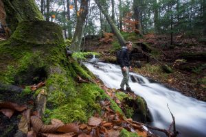
- Dark Hollow Brook / Flat Brook Falls –★★★– 5.9 miles – Remote and rugged terrain past a cascading waterfall then snaking between private property and town open space
- Parking on Toll Gate Road
- 2.8 mile road walk on Dickinson Rd to Toll Gate Road
- Parking off Dickinson Road
- Bald Hill to Rt 2 –★★– 4.9 miles – Uneventful hike on old CCC roads
- South Terminus: Great Hill Overlook –★★★– 3.6 miles – A steep climb to a great overlook of the CT River then on to tiny waterfall below Bald Hill
- Parking off Gadpouch Road
The trail first appears in the Fourth Edition of the Connecticut Walk Book in 1953. The trail had been started in 1952 and a handful of sections were underway in January 1953:
- From the fire tower on John Tom Hill in Glastonbury to present day Case Mountain Park
- Through the Shenipsit State Forest to Soapstone Mountain and onto Bald Mountain
- Great Hill to Bald Hill (not to be confused with Bald Mountain above) through blocks 24 and 22 of the Meshomasic State Forest
By 1962 seven sections were complete totaling about 30 miles of trail with a large gap from Bolton to Ellington. It’s interesting to see the trail maps before I-384 tore through the area (it first appears in the 1976 Walk Book). CFPA did complete sections from Bald Mountain north to Camp Aya-Po but still fell just shy of the planned end at Mass border at Rattlesnake Hill.
The majority of these sections have remained almost completely unchanged with minor connections being created along Birch Mountain Road. The large gap between Bolton and Ellington continued through the early 90s and the north end of the trail was clipped by a couple miles ending on Old County Road abandoning the stretch to Camp Aya-Po for unknown reasons.
By 2005 much of the major gaps had been filled in thanks to the Hop River Trail, Belding, and Tankerhoosen additions. Unofficial trail and road walks began to connect the last remaining gaps by 2010. In 2010, the CFPA decided Route 2 was becoming too busy to safely cross so they created the current 2.8 mile road walk around/over it.
By 2014 the last of the unofficial trails/roadwalks had been blazed and the Shenipsit became a complete thru-hike trail with the north end extended to its current terminus on Greaves Road. Around 2018 the CFPA attempted to get a ledge built in the culverts under Route 2 to avoid the roadwalk but the DOT decided against the plan.
{{locationDetails}}
