
Explore Glastonbury, CT
Glastonbury at a Glance
Part of Hartford County
If you’re looking for the best hiking trails in Glastonbury this is the complete guide to all the long trails, waterfalls, and history it has to offer.
My Highlights
Coming soon!
Hiking
Town Parks
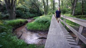
- Addison Bog Walk –★★– 1.8 miles – Dominated by the Bell-Hebron Linear Park which is a popular paved biking path for an easy stroll, there are rough trails through the woods for those willing to explore and find the anti-climatic bog
- Blackledge Falls –★★★– 2 miles – Short but popular trails with a small waterfall and connections to Gay City State Park
- Buckingham Park –★– 1.5 miles – Not to be confused with nearby Buckingham Reservoir this small park is mainly a playscape and ballfields though has a short loop trail through the woods
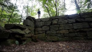
- Cotton Hollow –★★★★– 1.2 miles – A very popular spot year round for short hikes, swimming in Roaring Brook, and views of historical ruins
- Earle Park –★★– 1.2 miles – Behind the former Audubon Center, confusing trails wander to a unexpected view of the Connecticut River
- Ferry Landing – Unexplored
- Great Pond Reserve –★★– 2 miles – A bit hidden but trails lead to a small pond, and old cedar tree, and high banks along the CT River
- J.B. Williams Park –★★– 3 miles – Well traveled trails, lean-to camping for residents, and a small pond for fishing
- Matson Hill Open Space – Unexplored
- Richard Strong Memorial Open Space – Unexplored
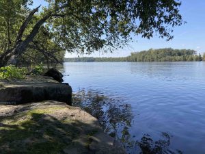
- Riverfront Park –★★– 1 mile – A popular boat launch into the Connecticut River, a level crushed stone walking path, and plenty of ballfields and open space
- Shoddy Mill Preserve –★★– 2 miles – Rough trails loop through the woods in two sections here with views of the Shoddy Mill ruins
- Smut Pond – Unexplored
- Tiboni Property – Unexplored
Land Trust
- Kongscut Land Trust – I’m not certain which properties have trails so this is a lightly edited list, all are but Hollister are unexplored
- Booth Woods Preserve
- Drumlin Hill Preserve
- Fern Hollow Preserve
- Goodale Hill Preserve
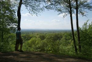
- Hollister Preserve/Whitehouse Family Nature Preserve –★★– 2.2 miles – 1.5 mile loop trail along Smith Brook and up to a vista with great views of the Hartford skyline
- Landa Family & Costabile Preserve
- Scoville Tract
- Swan Estate & Riley Parcel
- Zihrup Open Space Preserve
- Kongscut Land Trust – I’m not certain which properties have trails so this is a lightly edited list, all are but Hollister are unexplored
State Parks / Forest
- Not technically “in”, but Gay City State Park has trails that connect into Glastonbury
- Meshomasic State Forest
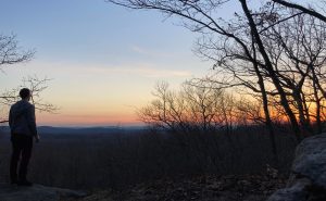
- Kongscut Mountain & Phillips Cave Loop –★★★– 5 miles – An overlook on one side of the road and a loop trail with a ledge ‘cave’ on the other
Blue Blaze
- Shenipsit Trail
- Shenipsit: Case Mountain –★★★– 2 miles – Though Case Mountain is a popular Manchester town park, the Shenipsit through the property is generally quiet and some of the best hiking in the park
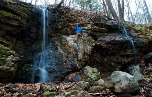
- Shenipsit Trail: Dark Hollow –★★– 5 miles – A rugged stretch of trail after Rt 2 with plenty of hills and valleys and a short spur trail to a long cascading waterfall
- Shenipsit Trail: Dickinson Rd –★★– 5 miles – Winding along a network of old woods roads this uneventful section has long gradual hills
- Shenipsit Trail
The Rest
- Buckingham Reservoir –★★★– 11 miles – A maze of popular mostly unblazed hiking and mountain bike trails centered around the reservoir with connections north to Case Mountain
- Case Mountain –★★★★– 12 miles – Largely a Manchester town park, the southern corner of the trail network is in Glastonbury
Boating/Fishing
- Connecticut River
- Riverfront Park – A popular boat launch into a winding sectiong of the Connecticut River
- Keeney Cove – Unexplored
- Connecticut River
Mountain Biking
- Buckingham Reservoir –★★★– 11 miles – A maze of popular mostly unblazed hiking and mountain bike trails centered around the reservoir with connections north to Case Mountain
- Case Mountain –★★★★– 12 miles – Largely a Manchester town park, the southern corner of the trail network is in Glastonbury
- Daybreak Coffee Roasters – Open daily 8am-4pm
33. Glastonbury, incorporated May, 1693; set off from Wethersfield, June, 1692; named from Glastonbury in Somersetshire.
{{label}}: {{displayValue}}
{{displayValue}}
{{displayValue}}
{{locationDetails}}
Browse sub-categories
Showing 1 result
Showing {{ showing }} out of {{ foundPosts }} results
