
Explore Woodstock, CT
Woodstock at a Glance
Part of Windham County
If you’re looking for the best hiking trails in Woodstock this is the complete guide to all the long trails, waterfalls, and history it has to offer.
Woodstock is the second largest town in the state (after New Milford), encompassing 61.8 square miles and has just shy of 2,500 acres of preserved land. These lands host:
- 10 hikeable areas with a dozen miles of trails
- 4 options for boating/fishing
- 1 disc golf course
My Highlights
- Connecticut’s newest blue blaze trail
- Great disc golf at Crystal Pond
Hiking
Town Parks
- Crystal Pond Park –★★★– 2.5 miles – Hiking, disc golf, and water access all in one spot, though hiking trails are a bit rough
- Fifty Acre Wood –★★– 1.5 miles – Nearly a forgotten town trail, somewhat overgrown loop
- Muddy Pond – Woodstock Town Beach open to town residents only, no boating
Land Trust
- New England Forestry Foundation
- Goodell Morse Community Forest – No trails but exploration is allowed
- New Roxbury Land Trust
- Bishop Preserve – No marked trails
- Border Woods – Off Rt. 198, about 200ft of “trail” that dead ends quickly at private property
- Kenyon Woods – No marked trails
- Wyndham Land Trust
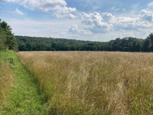
- Cabbage Hill –★★– 1.5 miles – Mowed paths to a great field view and an old cemetary
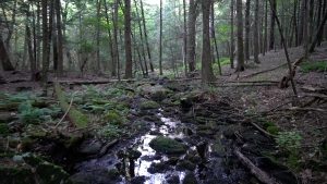
- Cartier Preserve –★★– 1.2 miles – New unblazed trail through an ocean of ferns and dense mountain laurel
- Little River Greenway –★– 0.15 miles – Very short boardwalk with no views
- Rapoport Preserve –★– 1.5 miles – Likely nicer in the winter, these trails are overgrown without much to note
- Rocky Hill Refuge –★– 0.5 miles – Skip this out and back field-access road
- New England Forestry Foundation
State Parks / Forest
- Nipmuck State Forest – Old woods roads in this section adjacent to Bigelow Hollow
Blue Blaze
- Wabbaquasset Trail –★★★– 1.3 miles – The state’s newest blue blaze trail is a picturesque loop through Hibbard Forest
The Rest
- Lem Walker Loop at Hatchet Hill – Private property, great overlook, but not open to the public
- The Old Connecticut Path – Historical path
- Roseland Park – ‘Private park’ open to the public since 1876 with easy walking paths, a boat launch, and many amenities
Boating/Fishing
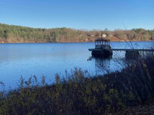
- Black Pond – 77 acre pond next to the YMCA camp
- Crystal Pond – 148 acre pond with a developed shoreline
- North Running Brook Fishing Hole – A couple fishing spots on either side of Joy Road
- Roseland Lake – Fishing is considered excellent in this 90 acre state stocked lake
Disc Golf
- Crystal Pond – Popular 18 hole disc golf course
- Farm to Table Market – Great farm store with local meats, milk in glass bottles, and other local products
- Soleil Bakery – Thursday-Sunday 10-6pm – Old fashioned bakery items, old world breads, and personalized cake options
- Woodstock Trading Post – Formerly Sweet Evalina’s
- Taylor Brook Winery and Brewery – Two separate buildings for tastings and casual hang out spots
- Tree House Farm Brewery – A Connecticut expansion of the popular brewery on gorgeous property formerly the Devon Point Farm
Geologically a glacial drumlin field. The area was historically home to the Wabbaquasset tribe or band meaning “mat producing country” part of the larger Nipmuck tribe. The Old Connecticut Path which ran from the Connecticut River to modern day Boston passed through Woodstock above Crystal and Woodstock Ponds. At the time the settlers came, Wabbaquasset country was held by the Mohegan Uncas as a Pequot conquest. The land was formally deeded to Captain James Fitch in 1680 and in 1686, residents from Massachusetts settled the area and called it New Roxbury.
The Puritan missionary John Eliot encouraged the Native Americans to form a village of “Praying Indians” in South Woodstock. He called it Wahbuquoshish meaning “near the bend in the outlet from Woodstock Pond.” In 1934, Arthur Basto, an amateur archeologist, confirmed that this village was located near Woodstock Pond, on the site of the William Basto Farm.
While largely agricultural in nature, “by 1820, there were 2 distilleries, 2 wheel wrights, an oil mill, fulling mill, carding machines, grist mills, saw mills, a goldsmith, and twine and cotton batting operations. Woodstock Valley was known for its shoe factories,” according to the history page at the Woodstock town site. Industry didn’t last long, reverting to a rural town and becoming a summer destination for wealthy city dwellers.
{{locationDetails}}
