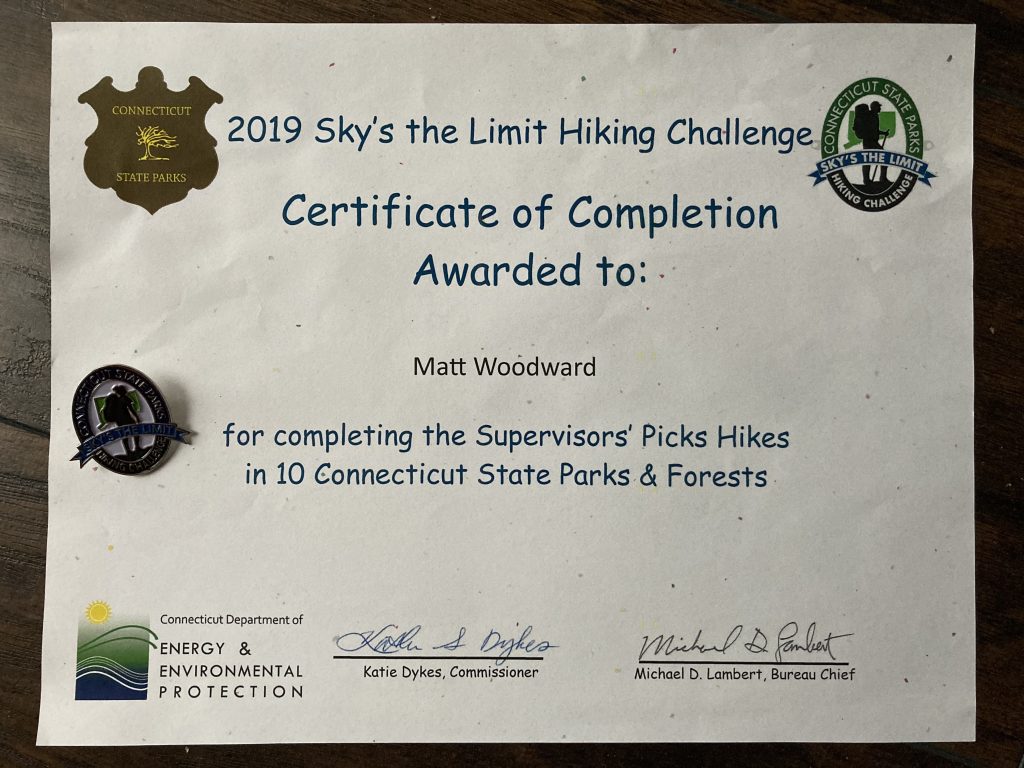
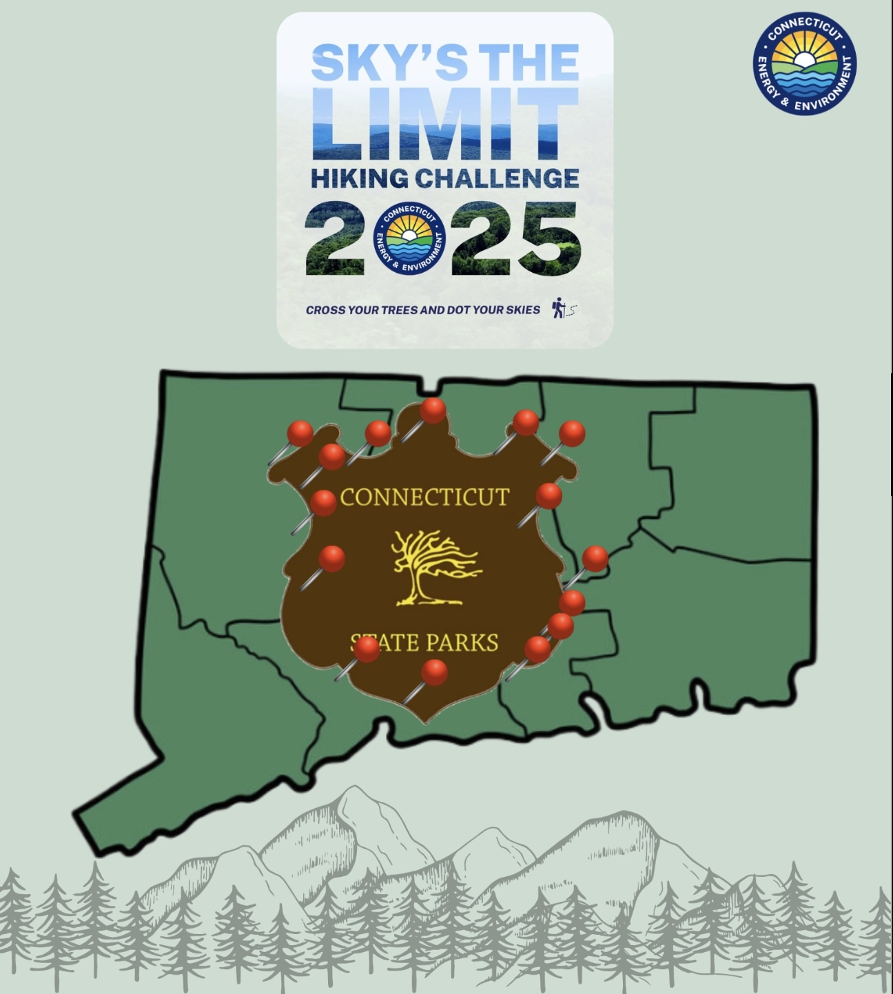
Sky's the Limit

Sky’s the Limit Hiking Challenge

The Sky’s the Limit Hiking Challenge is a program put on annually by the DEEP since 2015.  Each year DEEP staff pick 15 locations (upped from 14 to 20 in 2021-22) around the state to explore some element of the park around a common theme.  To participate, hikers must take photos of  designated locations within each park and submit them before the deadline.

Hiking and photographing 10 of the chosen parks will earn a medallion or lapel pin and certificate.  Completing all 15 puts you in a drawing to win one of 50 hand-carved hiking staffs announced at a First Day event on January 1st of the following year.

I have participated each year, but visited only a handful every time.  2019 was my first year completing the challenge and I made a movie documenting it.

Former Challenge Lists

2015 Theme - Towers and Lookouts

(DEEP Archive Link)

  • 1: Talcott Mountain State Park, Simsbury/Bloomfield
  • 2: Haystack Mountain State Park, Norfolk
  • 3: Dennis Hill State Park, Norfolk
  • 4: Southford Falls State Park, Southbury
  • 5: Hurd State Park, East Hampton
  • 6: Shenipsit State Forest (Soapstone Mtn.), Somers
  • 7: Sleeping Giant State Park, Hamden
  • 8: Lovers Leap State Park,
  • 9: Macedonia Brook State Park,
  • 10: West Rock Ridge State Park,
  • 11: Mohawk Mountain State Forest,
  • 12: Mount Tom State Park,
  • 13: Fort Griswold Battlefield State Park, Groton
  • 14: Pachuag State Forest (Mount Misery), Voluntown

2016 Theme - Bodies of Water

(DEEP Archive Link)

  • 1. Dinosaur State Park, Rocky Hill
  • 2. Collis P. Huntington State Park, Redding
  • 3. Burr Pond State Park, Torrington
  • 4. American Legion State Forest, Barkhamsted
  • 5. Mansfield Hollow State Park, Windham/Mansfield
  • 6. Black Rock State Park, Watertown
  • 7. James L. Goodwin Forest, Hampton
  • 8. Windsor Locks Canal Trail State Park, Windsor Locks/Suffield
  • 9. Squantz Pond State Park, New Fairfield
  • 10. Millers Pond State Park, Duham/Haddam
  • 11. Mianus River State Park, Stamford
  • 12. Air Line State Park Trail (CTMARI Tri-point), Thompson
  • 13. Devil’s Hopyard State Park, East Haddam
  • 14. Bluff Point State Park, Groton

2017 Theme - Historic Sites

(DEEP Archive Link)

  • 1. Stratton Brook State Park (Stratton Brook Depot), Simsbury
  • 2. Bolton Notch State Park (Hop River Trail), Bolton
  • 3. Beckley Furnace Industrial Monument, East Canaan
  • 4. Topsmead State Forest (Barbeque Pit), Litchfield
  • 5. Bigelow Hollow State Park (Mashapaug Pond), Union
  • 6. Natchaug State Forest (Nathaniel Lyon Birthplace), Eastford
  • 7. Indian Well State Park (The Well), Shelton
  • 8. Air Line State Park, Blackledge River Bridge, Colchester
  • 9. Haley Farm State Park (Canopy Rock), Groton
  • 10. Gillette Castle State Park (Gillette Railroad Tunnel), East Haddam
  • 11. Chatfield Hollow State Park (Oak Lodge Nature Center), Killingworth
  • 12. Mashamoquet Brook State Park (Wolf Den), Pomfret
  • 13. Farmington Canal State Park Trail (Lock 12), Cheshire
  • 14. Putnam Memorial State Park (Officer’s Quarters/Magazine), Redding/Bethel

2018 Theme - “Lesser-known” Parks and Trails

(DEEP Archive Link)

  • 1. Housatonic Meadows State Park, Sharon
  • 2. Cockaponset State Forest, Guilford
  • 3. Naugatuck State Forest, Ansonia
  • 4. Seth Low Pierrepont State Park Reserve, Ridgefield
  • 5. Old Furnance State Park, Killingly
  • 6. Moosup Valley State Park Trail, Plainfield/Sterling
  • 7. Paugussett State Forest, Newtown
  • 8. River Highlands State Park, Cromwell
  • 9. Farm River State Park, East Haven
  • 10. Machimoodus State Park, Moodus
  • 11. Hopeville Pond State Park, Griswold
  • 12. Sunnybrook State Park, Torrington
  • 13. Day Pond State Park, Colchester
  • 14. George Dudley Seymour State Park, Haddam

2019 Theme - Staff Picks

(DEEP Archive Link)

  • 1. Mohawk State Forest, Sharon
  • 2. Kettletown State Park, Southbury
  • 3. Rocky Neck State Park, East Lyme
  • 4. Barn Island Wildlife Management Area, Stonington
  • 5. James L. Goodwin State Forest, Hampton
  • 6. Pachaug State Forest – Green Falls Area, Voluntown
  • 7. Salt Rock Campground, Sprague
  • 8. Mount Tom State Park, Litchfield
  • 9. Harkness Memorial State Park, Waterford
  • 10. Wadsworth Falls State Park, Middletown
  • 11. American Legion and Peoples State Forest, Barkhamsted
  • 12. Macedonia Brook State Park, Kent
  • 13. Dennis Hill State Park, Norfolk
  • 14. Horse Guard State Park, Avon

2020 Theme - DIY 'Paths Less Traveled'

(DEEP 2020 Link)

This year’s theme was supposed to be ‘Bridges and Boardwalks’ but was delayed until October 5th and was changed to 9 locations of your choice:

  • 3 State Parks
  • 3 State Forests
  • 3 Blue Blue Blazed Hiking Trails

2021 Theme - Bridges, Footbridges, and Boardwalk

(DEEP 2021 Link)

  • This year the total number of hikes has increased to 20.  Completing all 20 will make you eligible to win one of 50 hiking staffs and completing 15 will receive a medallion and certificate.
  1. Dinosaur State Park
    • Photo Locations (5):  Trail information building, boardwalk at start, pick one of the Interpretive signs on the trail, decorated bat box, boardwalk on blue trail
  2. Lovers Leap State Park
    • Photo Locations (4): Iron Bridge, Highlights of Lovers Leap State Park Interpretive sign, Indian Spring House, photo of your choosing
  3. Silver Sands State Park
    • Photo Locations (2):  New Concession building, Bench with viewing scope on the boardwalk
  4. Hammonasset State Park
    • Photo Locations (3):  Plaque on the rock before heading onto the trail, photo looking out from the viewing platform towards Long Island Sound, interpretive signage on the viewing platform
  5. Black Rock State Park
    • Photo Locations (3):  Footbridge, Bridge, photo from the area labeled on the map as scenic vista
  6. Chatfield Hollow State Park
    • Photo Locations (4):  The History of Chatfield Hollow and The Paul F. Wildermann Boardwalk interpretive sign, Red Covered Bridge, any other bridge, footbridge or boardwalk along the hiking/walking area
  7. Collis P. Huntington State Park
    • Photo Locations (2):  Trail bridge of your choosing and the Collis P. Huntington State Park signage with hand drawn trails and hand drawn explanation (key)
  8. Southford Falls State Park
    • Photo Locations (3):  Covered Red Bridge, bridge near parking lot, boardwalk on the Red Trail
  9. Wharton Brook State Park
    • Photo Locations (2):  Bridge over Wharton Brook and the Pitch Pine Natural Area Preserve sign
  10. Wadsworth Falls State Park
    • Photo Locations (2):  Covered Bridge and the stone arch bridge
  11. Peoples State Forest
    • Photo Locations (3):  Agnes Bowen Trail/Robert Ross Trail signs, pick one of the Interpretive signs leading to or on the boardwalk/viewing platform, view out into the wetland along the boardwalk
  12. Ferry Landing State Park
    • Photo Locations (5):  Photo of How Well Do you Know Boating kiosk, photo of railroad bridge, photo of Blue Crab Regulations sign, photo of osprey platform Interpretive signage with island/osprey platform in background; and photo of the CT River from anywhere along the timber walkway or timber boardwalk
  13. Kent Falls State Park
    • Photo Locations (3):  Covered Red Bridge, timber footbridge, Bridge on Dugan Road (at the end of the Red Trail)
  14. Cockaponset State Forest
    • Photo Locations (4): 2 bridge locations/crossings along the Blue Trail, Collier’s Hut Remains, and Observation Tower Remnants
  15. Sherwood Island State Park
    • Photo Locations (3): Living 9/11 memorial, 2 locations (stops) along the Nature Trail
  16. Devil’s Hopyard State Park
    • Photo Locations (2): Covered bridge along the Eight Mile River, and a photo taken from the area marked on the map as Scenic View
  17. Stratton Brook State Park
    • Photo Locations (2): Covered Bridge and the timber boardwalk on the Orange Trail
  18. Salmon River State Forest
    • Photo Locations (2): Covered bridgearea labeled Salmon River Trail Scenic Vista
  19. Osbornedale State Park
    • Photo Locations (3): Boardwalk/footbridge across from Osborne Homestead Museum, a geologic feature found along the Red Trail, and boardwalk located along the trail
  20. Rocky Neck State Park
    • Photo Locations (4): Anywhere on the beach boardwalkBride Brook, intersection of the White/Purple Trail, intersection White/Red Trail

2022 Theme - 'Best Kept Secrets'

(DEEP 2022 Link)

2022’s theme was ‘Best Kept Secrets‘. Hike and photograph 15 for a certificate and medallion.  Hike and photograph all 20 to enter a drawing to win one of 50 hand carved hiking staffs. All entries were due by 3 pm on Friday, December 2, 2022.

DEEP Officials Sky’s the Limit Link 2022

  1. Gillette Castle State Park in East Haddam
    • Trail Names: Purple Trail – Train Tunnel Trail (1.14 miles) and the Blue Trail (.34 miles) leading down to the CT River.
    • Photo Locations (4): Gillette Castle signage, Gillette Castle, the train tunnel on Purple Trail, Osaki House and Aunt Polly by the water (best to see at low tide)
  2. Goodwin State Forest in Hampton
    • Trail Names: Richard D. Haley Nature Plant Wildlife Gardens and the .5 mile Forest Discovery Trail
    • Photo Locations (3): Goodwin State Forest or James L. Goodwin Conservation signage, anywhere within the Richard D. Haley Nature Plant Wildlife Garden, any area of the Forest Discovery Trail
  3. Topsmead State Forest in Litchfield
    • Trail Names: Red Trail (1 mile) and the Edith Morton Chase Ecology Trail (.7 miles)
    • Photo Locations (3): Topsmead State Forest signage, signage inside of the viewing stand, one of the interpretive signs on the Edith Morton Chase Ecology Trail
  4. Sessions Woods Wildlife Management Area in Burlington
    • Trail Name: Beaver Pond Trail (2.6 mile)
    • Photo Locations (3): Session Woods Wildlife Management Area Signage, area of Beaver Marsh, view looking out from the Summer House
  5. Sleeping Giant State Park in Hamden
    • Trail Name: Nature Trail (1.8 miles)
    • Photo locations (3): Sleeping Giant State Park signage, photo of 2 different areas along the Nature Trail that you find unique or interesting
  6. Penwood State Park in Bloomfield/Simsbury
    • Trail Name: Loop Road Trail (3.0 miles)
    • Photo Locations (3): Penwood State Park signage, photo taken from the viewing platform by Lake Louise, area of the picnic pavilion (near Penwood Pond)
  7. Bluff Point State Park & Coastal Reserve in Groton
    • Trail Name: Gravel Road (3.45 miles) in Bluff Point
    • Photo Locations (4): Bluff Point State Park signage, photo of the scenic view at the end of Bluff Point (shown as scenic view on the map), Sunset Rock (as shown on map) and Winthrop House foundation and signage
  8. Harkness Memorial State Park in Waterford
    • Trail Name: Take the Harkness Memorial Loop (1.3 mile) and the Niering Walk (.25 miles)
    • Photo Locations (5): Harkness Memorial State Park signage, photo from the Wildlife Viewing Platform on the Niering Walk, photo of/from the boardwalk as shown on the map, photo of one of the gardens, and a photo of the Mansion known as Eolia
  9. Gay City State Park in Bolton, Glastonbury and Hebron
    • Trail Names: Roadway to White Trail to Red/White Trail, to White Trail, to Blue Trail to Roadway (3.1 miles)
    • Photo Locations (4): Gay City State Park signage, gravestone area, mill Ruins/stone foundations, and a photo of one of the footbridges along the trail
  10. Mansfield Hollow State Park in Mansfield/Windham
    • Trail Name: Yellow Trail to the Flood Control Levee (1.75 miles)
    • Photo Locations (3): Mansfield Hollow State Park signage, Flood Control Levee signage, photo from any location looking out along/from the Flood Control Levee
  11. Bolton Notch State Park to the Hop River State Park Trail in Bolton/Andover
    • Trail Name: Hop River State Park Trail starting in Bolton Notch State Park (4.5 miles)
    • Photo Locations (5): Bolton Notch State park signage, Hop River State Park signage, Bolton Notch tunnel, photo of a rock formation along the trail, photo of an interesting “find” along the trail (could be anything-the trail, an animal, building, tree, etc.)
  12. West Rock Ridge State Park in Hamden/New Haven
    • Trail Name: Red Trail to White Trail looping around Lake Wintergreen
    • Photo Locations (3): Lake Wintergreen signage, view of Lake Wintergreen from the trail, photo of an interesting feature or find on your hike (i.e teepees, animals, trees or tree root, etc.)
  13. River Highlands State Park in Cromwell
    • Trail Name: White Trail, Scenic View (1 mile)
    • Photo Locations (3): River Highlands State Park signage, photo from the area marked as scenic view on the map, photo from anywhere along the trail
  14. Enders State Forest in Granby/Barkhamsted
    • Trail Name: Enders Falls loop purple trail
    • Photo Locations (3): Enders State Forest signage, photo of the trail, and a photo of the Falls
  15. Fort Trumbull State Park in New London
    • Trail Name: Riverfront Walk of historic sites (1.3 miles)
    • Photo Locations (3): Fort Trumbull State Park signage, photo from inside or outside of the Fort, photo on or from the Fort Trumbull Fishing Pier
  16. Fort Griswold Battlefield State Park in Groton
    • Trail Name: Six stop cell phone walking tour of Fort Griswold (.5 miles)
    • Photo Locations (4): Fort Griswold Battlefield State Park signage, photo of the monument or looking out from the monument, cell phone tour post and signage, view looking out from the constructed deck at Fort Griswold of the property
  17. Farm River State Park in East Haven
    • Trail Names: Shoreline Greenway Trail ( .6 miles) and the Farm River Nature Trail Please note: best to do during low tide conditions.
    • Photo Locations (4): Farm River State Park signage, Shoreline Greenway Trail signage, photo taken along the Shoreline Greenway Trail, and a photo taken along the Nature Trail
  18. Putnam Memorial State Park in Redding
    • Trail Name: Gravel Road loop and loop around the Museum (1 mile)
    • Photo Locations (5): Putnam Memorial State Park signage, photos of 3 of the marked historic sites on-site (3 photos), and any other photo of your choosing
  19. Beckley Furnace Industrial Monument in North Canaan
    • Trail Name: Walk the monument grounds at Beckley Furnace and visit the Industrial Monument (.25 miles)
    • Photo Locations (3): Beckley Furnace Industrial Monument signage, Beckley Iron Furnace, any other photo of the grounds or the furnace
  20. For the 20th hike choose your own favorite CT State Park or Forest location, a feature within such park or forest, or what trail you feel is the “Best Kept Secret” here in CT.  Please tell us the location, why it’s the Best Kept Secret” and share your photos with us.  We are looking forward to hearing from you!**

2023

This year’s theme is ‘In, Under, Over or Through’ featuring five rails-to-trails and ten state parks. Hike and photograph 10 for a certificate and medallion.  Hike and photograph all 15 to enter a drawing to win one of 50 hand carved hiking staffs. All entries were due by 3 pm on Friday, December 1st, 2023 ideally through the official Google Form.

  1. Air Line State Park Trail in Portland, East Hampton, Colchester, Hebron, Columbia, Lebanon, Windham, Chaplin, Hampton, Pomfret, Putnam, and Thompson
    • Trail Name: Air Line Trail State Park
    • 3 Photo Locations: Air Line State Park Trail sign/signage/kiosk, feature along the trail (i.e bridge, tunnel, stonework, stand of trees, wall, pond, stream, gate, path, building, etc.), photo of the participants choosing from along the trail
  2. Larkin State Park Trail in Middlebury, Naugatuck, Oxford, and Southbury
    • Trail Name: Larkin State Park Trail
    • 3 Photo Locations: Larkin State Park Trail sign/signage/kiosk, feature along the trail (i.e bridge, tunnel, stonework, stand of trees, wall, pond, stream, gate, path, building, etc.), photo of the participants choosing from along the trail
  3. Moosup State Park Trail in Plainfield and Sterling
    • Trail Name: Moosup Valley Trail
    • 3 Photo Locations: Moosup State Park Trail sign/signage/kiosk, feature along the trail (i.e bridge, tunnel, stonework, stand of trees, wall, pond, stream, gate, path, building, etc.), photo of the participants choosing from along the trail
  4. Farmington Canal Heritage Trail in Avon, Burlington, Canton, Cheshire
    • Trail Name: Farmington Canal Heritage Trail
    • 3 Photo Locations: Farmington Canal Heritage Trail sign/signage/kiosk, feature along the trail (i.e bridge, tunnel, stonework, stand of trees, wall, pond, stream, gate, path, building, etc.), photo of the participants choosing from along the trail.
  5. Hop River State Park Trail in Andover, Bolton, Columbia, Coventry, Manchester and Vernon
    • Trail Name: Hope River State Park Trail
    • 3 Photo Locations: Hop River State Park Trail sign/signage/kiosk, feature along the trail (i.e bridge, tunnel, stonework, stand of trees, wall, pond, stream, gate, path, building, open space area, etc.), photo of the participants choosing from along the trail.
  6. Auerfarm State Park in Bloomfield
    • Trail Names: Orchard Loop (Red), Garden Loop (Green), Blueberry Loop (Blue), Farm Trail (Red) and Mushroom Trail (Yellow)
    • 3 Photo Locations: Auerfarm State Park sign/signage/kiosk, take a photo from somewhere along the Farm Trail (ideas for potential photos-apple barn, birds, wildflowers, etc.), and a photo of the participants choosing from along one of the 5 trails on-site.
  7. Windsor Locks Canal State Park Trail in Windsor Locks and Suffield
    • Trail Name(s): Windsor Locks Canal State Park Trail
    • 3 Photo Locations: Windsor Locks Canal State Park Trail sign/signage/kiosk, feature along the trail (i.e bridge, stonework, stand of trees, wall, CT River, fence, gate, building), photo of the participants choosing from along the trail.
  8. Mianus River State Park in Stamford
    • Trail Name: Nature Trail
    • 3 Photo Locations: Mianus River State Park sign/signage/kiosk, Point of Interest along the Nature Trail, and a photo of the participants choosing from along the Nature Trail or within the park.
  9. Mount Riga State Park in Salisbury
    • Trail Name: Undermountain Trail
    • 3 Photo Locations: Mount Riga State Park or Undermountain Trail sign/signage/kiosk, interesting feature along the trail or a view from the top of the trail, and a photo of the participants choosing from along the trail
  10. Hopemead State Park in Bozrah and Montville
    • Trail Name: Unnamed/unblazed trail
    • 3 Photo Locations: Hopemead State Park sign/signage/kiosk, stone chamber/root cellar, photo of the participants choosing from along the trail or the lake.
  11. Camp Columbia State Park in Morris
    • Trail Names: Green Trail and Red Trail
    • 3 Photo Locations: Camp Columbia State Park sign, signage, kiosk, Observation Tower inside/outside or photo of the view from the Observation Tower, photo of the participants choosing from along the Red Trail
  12. Mount Tom State Park in Litchfield
    • Trail Name: Yellow Tower Trail
    • 3 Photo Locations: Mount Tom State Park sign/signage/kiosk, Stone Tower inside/outside or photo taken looking out from the Tower, photo of the participants choosing from anywhere along the trail
  13. Haystack Mountain State Park in Norfolk
    • Trail Name: Yellow Haystack Tower Loop Trail
    • 3 Photo Locations: Haystack Mountain State Park sign/signage/kiosk, Stone Tower at the summit or photo taken looking out from the Tower, photo of the participants choosing from anywhere along the trail
  14. Chatfield Hollow State Park in Killingworth
    • Trail Name: Green Caves Trail
    • 3 Photo Locations: Chatfield Hollow State Park sign/signage or kiosk, pick your favorite cave and take a photo of it, photo of the participants choosing from anywhere along the Green Trail/Cave trail or along another trail in the park
  15. Machimoodus State Park in East Haddam
    • Trail Names: Upper Vista Trail, Purple Trail and Lower Vista Trail
    • 3 Photo Locations: Machimoodus State Park sign/signage or kiosk, photo of the participants choosing anywhere along the Upper Vista Trail, photo of the participants choosing anywhere along the Lower Vista Trail (scenic viewing areas are recommended)

Moosup Valley State Park Trail

★★☆☆☆

2-58 Withey Hill Rd, Moosup, CT, USA

Moosup Valley State Park Trail Connecticut State Park 62 acres in Plainfield and Sterling, CT Parking: West End – Few spots near 2-58 Withey Hill Rd, Moosup,…

Windsor Locks Canal State Park

★★☆☆☆

41.986295, -72.605278

Windsor Locks Canal State Park Connecticut State Park 4.5 miles in Suffield and Windsor Locks, CT Parking: North End: Medium lot near near 1212-1100 Canal Rd  Suffield,… Read more…

Chatfield Hollow State Park

★★★★☆

41.365949, -72.585291

Chatfield Hollow State Park Connecticut State Park 412 acres in Killingworth, CT Parking: Lots near 381 CT-80, Killingworth, CT Trail Map         Trails: 5 miles …

Auerfarm State Park

★★☆☆☆

41.814364, -72.767321

Auerfarm State Park Connecticut State Park / Scenic Reserve 40 acres in Bloomfield, CT Parking: Small lot near 50 Auer Farm Road, Bloomfield, CT Trail Map   …

Mianus River State Park

Unexplored

41.085348, -73.588012

Mianus River Connecticut State Park / Scenic Reserve / Stamford Town Park / Greenwich Town Park 527 acres in Stamford, CT Parking: One lot and two small…

Mount Riga State Park

★★★★☆

Salisbury, CT 06068

Mount Riga State Park Connecticut State Park 276 acres in Salisbury, CT Parking: Medium sized lot near 339 Under Mountain Rd, Salisbury, CT Trail Map       …

Mount Tom State Park

★★★☆☆

41.692952, -73.273396

Mount Tom State Park Connecticut State Park 231 acres in Litchfield, Morris, and Washington, CT Parking: Large lot near 27 Mt Tom Rd, New Preston, CT Trail Map   … Read more…

Machimoodus State Park

★★☆☆☆

41.500551, -72.479695

Machimoodus State Park Connecticut State Park 300 acres in East Haddam, CT Parking: Medium lot at 128 Leesville Rd, Moodus, CT Trail Map         Trails: 4…

Hopemead State Park

★★☆☆☆

41.517336, -72.217250

Hopemead State Park Connecticut State Park 60 acres in Bozrah and Montville, CT Parking: Small lot near 28 Cottage Road, Bozrah, CT  Trail Map     Trails: Less…

Haystack Mountain

★★★★★

42.005899, -73.211236

Haystack Mountain State Park Connecticut State Park 292 acres in Norfolk, CT Parking: Small lot by following the road near 199 CT-272 Norfolk, Connecticut Trail Map     …