
The New England Trail Guide
New England Trail at a Glance
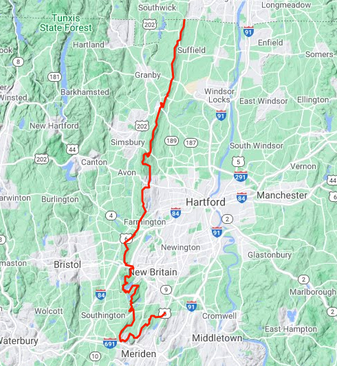
The New England Trail is a 235-mile hiking trail through Connecticut and Massachusetts.
This guide will focus on the 110 mile Connecticut portion largely maintained by volunteers of the Connecticut Forest and Park Association in cooperation with the National Park Service.
Designated a National Scenic Trail on March 30, 2009, it travels through classic New England landscape from the shores of Long Island Sound and along the spine of the Metacomet Ridge exploring rural vistas, farmland, large forests, and river valleys.
The trail also travels through several colonial historical landmarks and highlights a range of diverse ecosystems and natural resources including mountain ridges, summits, forested glades, wetlands and vernal pools, lakes, streams, and waterfalls. The trail is most often completed by section hiking.
Thru-Hiking
While the trail can be thru-hiked, there are only four camping areas making backpacking next to impossible to do legitimately. Water is also scarce along the ridge making resupply an issue. Amenities are underdeveloped and most hikers don’t know that it is a trail on par with the Appalachian Trail. There is about 11,000 ft of elevation gain in the Connecticut portion making this a moderate challenge that can feasibly be completed in about 5 days.


Highlights
Links
- New England Trail Official Website
- Guthook Guides – Official App/Guide
- National Park Service – New England Trail
- Connecticut Ultra Traverse (CUT) 112
- Fastest Known Time – Sean Meehan – 1d 6h 13m 56s on 2020-06-07
Section List
(North to South) Distances may be slightly off due to reroutes.
Metacomet Trail
- Closest parking north of the MA border
- Alcorn Preserve North Terminus – 2.3 miles – (Parking) Great views west along the ridges before descending to marshy areas at the Mass border
- Peak Mountain to West Suffield Mountain – 4.3 miles – (North Parking) (South Parking) Fantastic overlooks and a campsite through two towns
- Camping Area Windsor Locks Primitive Tentsite
- 0.2 mile road walk on Newgate Rd
- Tarrifville Gorge — 4.3 miles — (North Parking) (South Parking) Briefly along the Farmington River before rejoining the ridge and view of Connecticut whitewater
- Bartlett’s Tower — 0.5 miles — (Parking) More ridge line and a more impressive chimney from a former resort
- Wilcox Park — 1.8 miles — (Parking) Ridge line with an old chimney at Cedar Rock
- Penwood State Park – 3.4 miles – (Parking) Quieter section with a fantastic view at Pinnacle overlook
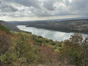
- Talcott Mountain State Park – 2.9 miles – (Parking) Climbing back to the ridge past iconic Heublein Tower to a steep descent
- Reservoir Number #6 – 1.8 miles – (Parking) Flat interlude along the western side of the popular reservoir
- Kilkenney Rock – 4.6 miles – (North Parking) (South Parking) Climbing among utility corridors to the perched erratic with mixed access roads and mountain bike trails along the ridge
- 2 mile mixed trail and road walk on Prattling Pond Rd, Metacomet Rd, and Old Mountain Rd
- Hill-Stead Museum — 0.6 miles — (Parking) Continues the ridge at the eastern edge of the property
- Farmington Reservoir – 0.8 miles – Up and over the ridge above the reservoir and past eagle rock
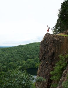
- Will Warren’s Den – 4.1 miles – (North Parking) (South Parking) Highlights include Pinnacle Rock overlook, Rattlesnake Ledges, Will Warren’s Den, and Hospital Rock
- 1.2 mile road walk over I-84 on Wooster St to Rt. 372
- Sunset Rock State Park — 3.6 miles — (Parking) A winding trail through strict rock features to the Crescent Lake overlook and ridges and then uneventful trail
- 0.8 mile road walk on Andrews St to Long Bottom Rd
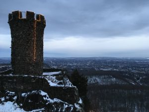
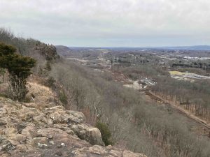
- Ragged Mountain — 5.2 miles — (Parking) One of the state’s most popular hikes with a handful of overlooks continuing along to the ridge south of Shuttle Meadow Reservoir
- 0.2 mile road walk on Carey St
- Short Mountain / Timberlin Park — 1.7 miles — (Parking) Rocky climb to northwest views from Short Mountain and a descent to hiker friendly private property
- 1.5 mile road walk on Edgewood Rd
- Hubbard Park / Castle Craig — 5.7 miles — (Parking) Enters the Hanging Hills and climbs to the castle tower on East Peak before turning north
- Blue Hills Conservation Area — 3.4 miles — (Parking) Unassuming start along a seasonal stream and rocky hills
- 2.6 mile road walk from Mattabesett Trail
Mattabesett Trail
- (North parking closed)
- Alice Fern Bruce Preserve – Last of the ridge before descending to a mixed road and trail
- Lamentation Mtn State Park – 3.3 miles – (North Parking)
- Camping Area Lamentation Mtn Primitive Tentsite
- Giuffrida Park – 3.5 miles – Parking – A U shaped hike over Chauncey Peak, down to the reservoir and up towards the west ridge
- Wilcox Woods – 0.8 miles – (Parking) Pleasant walk through pines and beginning to climb into Giuffrida
- 0.4 mile road walk on Atkins St.
- Highland Pond – 0.5 miles – CLOSED 6/1 – Fall 2025 Easy flat stretch with views of the pond and two short bridges
- 1.2 mile road walk Country Club Rd over I-91 to Bell St
- Wesleyan Woods Conservation Area – 1.7 miles – (Parking) Down off the ridge on a long abandoned old woods road
- Mt. Higby – 2 miles – (Parking Note: if you use the Higby Mountain Trail Head on Google Maps it will direct you to the Black Pond parking area) – Rugged hike with many great views
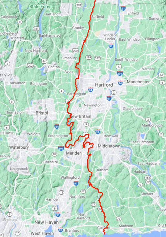
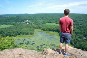
- Black Pond – 5.1 miles – (North Parking) (South Parking) – A long hike on the Beseck Mountain Ridge culminating in a cliff overlook of Black Pond
- 0.2 mile road walk on Rt. 68
- Tri-Mountain State Park – 4.1 miles (South Parking) – Climbing steeply again into this scenic reserve, a descent, and another very steep climb to a viewpoint
- Camping Area Cattails Shelter
- Pistapaug Mountain – 1.9 miles – Very long gradual climb to a nice viewpoint and an uneventful summit before a long rocky descent
- 0.5 mile road walk Stagecoach Rd to Rt 17
- Bluff Head – 3.9 miles (Parking) – Climb to overlook views before traveling through deep rolling woods
- Broomstick Ledges – 2.8 miles – (Bluff Head Parking) – Beautifully rocky winding trail over and between the ledges
- Junction with the Menunkatuck Trail
Menunkatuck Trail
- Junction with the Mattabesett Trail
- Broomstick Ledges – 0.2 miles – Beautifully rocky winding trail over and between the ledges
- Genesee Recreation Area – 3.6 miles – Gently rolling trail skirts the edge of this Water Authority property but doesn’t touch its history
- Cockaponset: Guilford North Parcel – 1.6 miles – (Parking) – Fairly standard old woods road with a “cave” passing the local Sportman’s Club
- Timberland Preserve – 2.6 miles – Crosses Iron Stream, passes Paradise Pool and the upper reaches of Upper Guilford Lake
- 0.2 mile road walk
- Nut Plain Woods – 1.7 miles – (Parking) – Long wetland board walk and unassuming woods between private property
- East River Preserve – 3.2 miles – (Parking) – Rocky along the East River to the open fields and through the woods
- 3.9 mile road walk
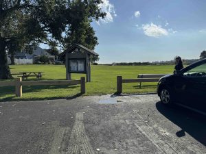
- Chittenden Park – 0.2 miles – (Parking) – From Long Island Sound, over a boardwalk, through the field, and onto the road
The New England Trail was designated a National Scenic Trail on March 30, 2009. It was formerly known as the M-M-M Trail (Mattabesett, Metacomet, and Monadnock) and in Connecticut was comprised of the entire lengths of the Mattabesett and Metacomet blue blaze trails.
However the goal was always for it to reach Long Island Sound which was developed and completed with the Menunkatuck Trail officially opening in 2014. This made the eastern most section (Rockland Preserve and east) of the Mattabesett superfluous though it still retains its federal designation and signage as part of the trail which occasionally causes some confusion.
The trail has largely remained unchanged in Connecticut since it was completed in 2014-15.
{{locationDetails}}