
Air Line Trail State Park
Trail at a Glance
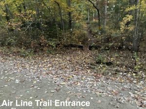
Stretching from Portland to Thompson the Air Line Trail runs for 50+ miles on the former New Haven, Middletown and Willimantic Railroad track.
Now a ‘Rails to Trails’ reconstruction, the Air Line is an easy walking path with many access points as well as connections to parks and preserves right off the trail. It is popular along its entire length with walkers, runners, and cyclists.
Highlights
Overlooks
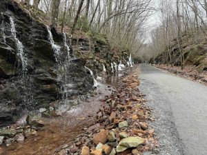
Waterfalls
Links
- CTMQ – Air Line Trail State Park Intro
- Peter Marteka – In East Hampton and Portland, a bridge and trail extensions fill the gaps along Air Line, Hop River rails-to-trails (2019)
- Peter Marteka – All Aboard Portland’s New Segment Of The Air Line Rail Trail (2018)
- Peter Marteka – Air Line Rail Trail a Gem (2001)
- Peter Marteka – Vestiges of Tracks Remain From 1891 ‘Ghost Train’ (1999)
Air Line Trail South
Air Line Trail North
Section List
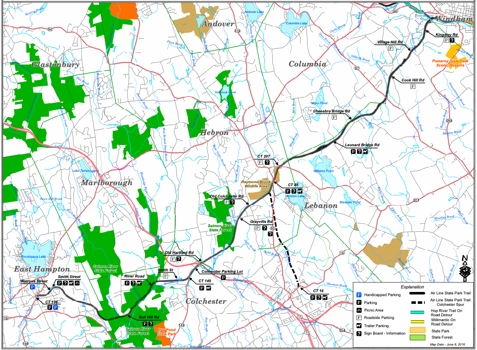
Air Line Trail South – 18.5 miles (Trail Map)
- Portland
- Current map of extension in progress
- Medium sized lot near 82 Middle Haddam Rd, Portland, CT
- Small lot near 179 Breezy Corners Rd Portland, CT
- Connection to Palmer Taylor Preserve
- East Hampton – 3.15 miles
- Small lot near 18 Depot Hill Rd, Cobalt, CT
- Small lot near 81 Main St, East Hampton, CT
- Small lot near 69 Smith St, East Hampton, CT
- This section contains one of Connecticut’s archaeological preserves with the Lyman Viaduct close to Bull Hill Rd
- Colchester – 4.15 miles
- Small lot near 280 Bull Hill Rd, Colchester, CT
- Small lot near 101 Westchester Rd, Colchester, CT
- Hebron – 3.75 miles
- Shoulder parking near 92 Grayville Rd, Amston, CT
- Connection to trails at Grayville Falls
- Small lot on Rt. 85 near 510 Church St, Amston, CT
- Small lot near 79 Lebanon Rd, Amston, CT
- Shoulder parking near 92 Grayville Rd, Amston, CT
- Lebanon – 7.5 miles
- Shoulder parking near 33 Leonard Bridge Rd Lebanon, CT
- Small lot near 9 Chesbro Bridge Rd, Lebanon, CT
- Small pull-off near 253 Cook Hill Rd, Lebanon, CT
- Picnic pavilion halfway between the two roads
- Small pull-off near 60 Village Hill Rd, Lebanon, CT
- Picnic seating close to Village Hill Rd
- Small pull-off near 100 Kingsley Rd, Lebanon, CT
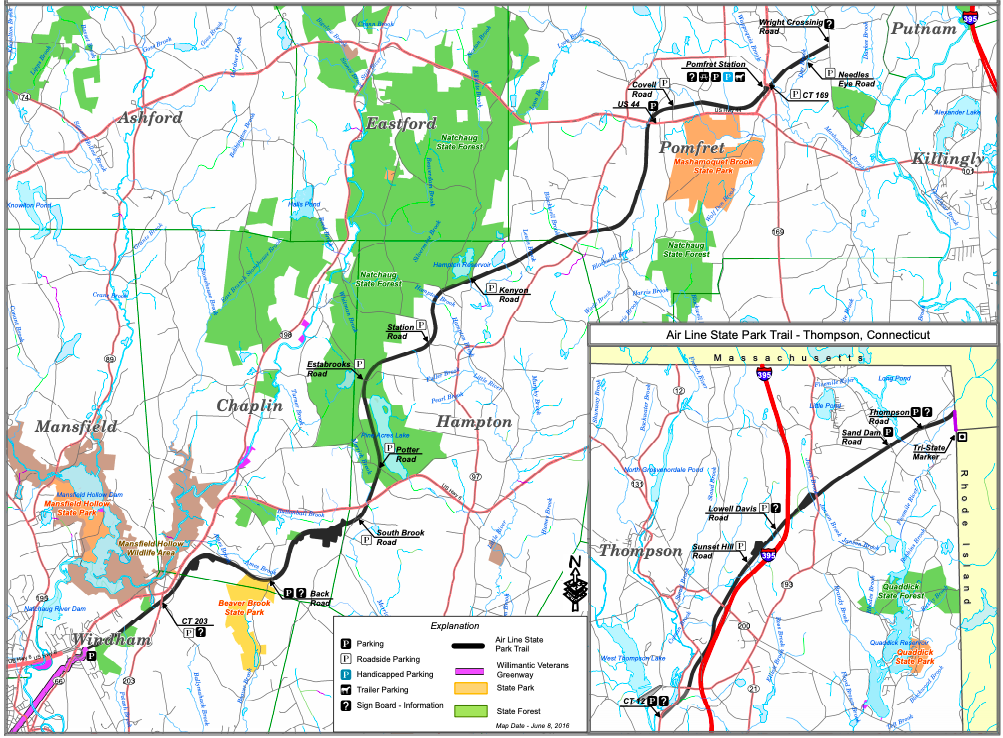
Air Line Trail North (Trail Map)
- Windham – 6 miles
- Junction with the Hop River Trail
- Small lot near 55 Bridge St, Willimantic, CT
- 2/3rds of a mile road stretch on Riverside Drive through Willimantic
- Small lots on either side of 460 Beaver Hill Rd, North Windham, CT
- Connection to trails at Two Sisters Tract
- Chaplin – 3.3 miles
- Small lot near 298 Lynch Rd Chaplin, CT
- Hampton – 6.8 miles
- Shoulder parking on Potter Rd Hampton, CT
- Connection to trails at Goodwin State Forest
- Shoulder parking near 86-46 Estabrooks Rd Hampton, CT
- Shoulder parking near 229 Station Rd Hampton, CT
- Connection to trails at Teale Woodlands
- Shoulder parking on Kenyon Rd Hampton, CT
- Connection to trail at Hampton Reservoir
- Connection to trail at Blue Flag Meadow
- Shoulder parking on Potter Rd Hampton, CT
- Pomfret – 7.7 miles
- Tiny lot on Rt. 97 near 917 Hampton Rd Pomfret Center, CT
- Connection to trail at Gellert/Valentine Preserve
- Connection to trail at Kimball Memorial Forest
- Connection to trails at Pomfret Forest
- Small lot near 5 Haven Rd, Pomfret Center, CT
- 1000′ road connection to Mashamoquet Brook State Park
- Small lot near 6 Railroad St, Pomfret Center, CT
- Connection to Duck Marsh Preserve
- Tiny lot on Rt. 97 near 917 Hampton Rd Pomfret Center, CT
- Putnam
- Current gap in the trail
- Putnam River Trail (Small lots along Kennedy Drive)
- Current gap in the trail (see March 2022 plan presentation)
- Thompson – 7.25 miles
- Small lot near 113 Riverside Dr Thompson, CT
- Shoulder parking near 301 Sunset Hill Rd, North Grosvenor Dale, CT
- Shoulder parking near 368 Sand Dam Rd, Thompson, CT
- Small pull-off near E Thompson Rd, Thompson, CT
- Connection to trail at Tri-State Marker East
The Mattabesett was the third trail created by the Connecticut Forest and Park Association and was completed in 1932. Students from Wesleyan University helped to clear and blaze the trail.
In 2009 it was added to the New England Trail
{{label}}: {{displayValue}}
{{displayValue}}
{{displayValue}}
{{locationDetails}}
Browse sub-categories
Showing 1 result
Showing {{ showing }} out of {{ foundPosts }} results