
Explore Putnam, CT
Putnam at a Glance
Part of Windham County
If you’re looking for the best hiking trails in Putnam this is the complete guide to all the long trails, waterfalls, and history it has to offer.
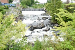
Putnam has three trails for 3.1 miles of hiking. There are views of Cargill Falls as well as limited fishing and boating along the Quinebaug River.
Hiking
Town Parks
- River Mill Heritage Trail –★★– 1.6 miles – Popular paved walking path along the east bank of the Quinebaug River with views of mill history and Cargill Falls
Land Trust
- Wyndham Land Trust
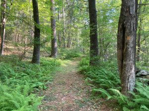
- Tamler Preserve –★★– 0.65 miles – Simple wooded lollipop loop with a rocky backside
- Wyndham Land Trust
State Parks / Forest
- Air Line Trail State Park –★★– 2.7 miles – Putnam is currently a gap in the trail, there is about 2.7 miles through the town but at least another 1.5 miles of road to rejoin the trail in Thompson
- See this March 2022 presentation for current plans
- Air Line Trail State Park –★★– 2.7 miles – Putnam is currently a gap in the trail, there is about 2.7 miles through the town but at least another 1.5 miles of road to rejoin the trail in Thompson
Blue Blaze
- None
The Rest
- Cargill Falls –★★– No trails – The River Heritage Trail passes this waterfall, but fences prevent all close access
Boating/Fishing
- Quinebaug River
- Boat launch at Simonzi Park (Parking Link)
- Fishing spots along the river
- Quinebaug River
Putnam was incorporated from lands of Pomfret, Thompson and Killingly in May 1855 making it the 156th oldest town in Connecticut.
It is named for Revolutionary War General Israel Putnam.
{{label}}: {{displayValue}}
{{displayValue}}
{{displayValue}}
{{locationDetails}}
Browse sub-categories
Showing 1 result
Showing {{ showing }} out of {{ foundPosts }} results
