
★★★☆☆
386 North St, Hebron, CT 06248
Gay City State Park Connecticut State Park 1,569 acres in Hebron, CT Parking: Large lot at 386 North St Hebron, CT year round with additional parking open…
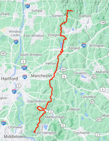
Traveling 50.2 miles from Portland to Stafford this blue blaze trail is maintained by volunteers coordinated by the Connecticut Forest and Park Association.
I thru-hiked the trail in June 2023 over the course of two days during peak mountain laurel bloom. Starting from the southern terminus at Great Hill I hiked 25.7 miles north to the Bolton Park and Ride which took me just over 10 hours. I returned the next morning to continue the hike traveling 24.5 miles to the northern terminus on Greaves Road which took me just under 10 hours.
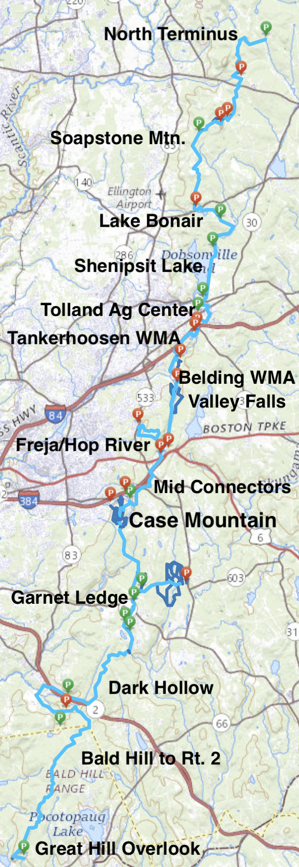
The trail starts with a bang at the Great Hill overlook of the Connecticut River, passes old mines touching on the history of central Connecticut, through the woods of the Connecticut’s oldest state forest before clambering around Route 2. There are miles of trails on old forest roads rutted by dirt bikes contrasted by miles of trails surrounded by beautiful mountain laurel. There are a handful of road walks and some sections that just exist to connect the trail. In the rugged northern stretches are deep fern forests, a tower overlook from the summit of 1075 ft Soapstone Mountain, and many hills before the trail whimpers to its current end short of the Massachusetts border on Greaves Road.
The name Shenipsit is a Native American word for ‘at the great pool’ which is attributed to Shenipsit Lake
The Shenipsit Striders hold an Annual End to End Run usually in the Fall each year. The fastest known time for running the Shenipsit Trail as of 2023 was set by Justin Kousky in September 2020 with a time of 8h 19m 21s.
The trail first appears in the Fourth Edition of the Connecticut Walk Book in 1953. The trail had been started in 1952 and a handful of sections were underway in January 1953. The first sections completed were:
By 1962 seven sections were complete totaling about 30 miles of trail with a big gap from Bolton to Ellington. It’s interesting to see the trail maps without I-384 (which appears in the 1976 Walk Book). They did complete sections from Bald Mountain north to Camp Aya-Po but still fell just shy of the planned end of at Mass border at Rattlesnake Hill.
The majority of these sections have remained almost completely unchanged since with minor connections being created along Birch Mountain Road. The large gap between Bolton and Ellington continued through the early 90s and the north end of the trail was clipped by a couple miles ending on Old County Road abandoning the stretch to Camp Aya-Po for unknown reasons.
By 2005 much of the major gap had been filled in thanks to the Hop River Trail, Belding, and Tankerhoosen additions. Unofficial trail and road walks began to connect the last remaining gaps by 2010. In 2010, the CFPA decided Route 2 was becoming too busy to safely cross so they created the current 2.8 mile road walk around/over it.
By 2014 the last of the unofficial trails/roadwalks had been blazed and the Shenipsit became a complete thru-hike trail with the north end extended to its current terminus on Greaves Road. Around 2018 the CFPA attempted to get a ledge built in the culverts under Route 2 to avoid the roadwalk but the DOT decided against the plan.

★★★☆☆
386 North St, Hebron, CT 06248
Gay City State Park Connecticut State Park 1,569 acres in Hebron, CT Parking: Large lot at 386 North St Hebron, CT year round with additional parking open…

★★★★☆
41.576774, -72.551996
Shenipsit Trail – South Terminus at Great Hill Connecticut Blue Blaze Trail – Shenipsit in Portland, CT Parking: Small lot and shoulder parking off gravel Gadpouch Rd…

★★★★☆
41.961605, -72.408513
Soapstone Mountain Connecticut State Forest 1800 acres in Ellington, Somers, and Stafford, CT Parking: Medium sized lot near 399 Gulf Rd, Somers, CT Trail Map …

★★★☆☆
41.669598, -72.503706
Shenipsit : Dark Hollow Brook to Flat Brook Falls Blue Blaze Shenipsit Trail and Connecticut State Forest in Glastonbury, CT Parking: Dark Hollow: At the end the road near… Read more…

★★☆☆☆
41.786520, -72.455719
Freja Park Bolton Town Park 21 acres in Bolton, CT Parking: Access from the Park & Ride off Rt. 44 or at Bolton Notch State Park Trail…

★★☆☆☆
41.831035, -72.447298
Belding Wildlife Management Area Connecticut State WMA 282 acres in Vernon, CT Parking: Lots of shoulder parking near 3 Bread and Milk Rd Vernon, CT Shoulder parking…

★★★★☆
68 Birch Mountain Rd, Manchester, CT
Case Mountain Manchester Town Park and Manchester Land Conservation Trust Property 640 acres in Manchester and Glastonbury, CT Parking: Four options (most popular to least): Case Pond… Read more…