Thru-Hiking the New England Trail


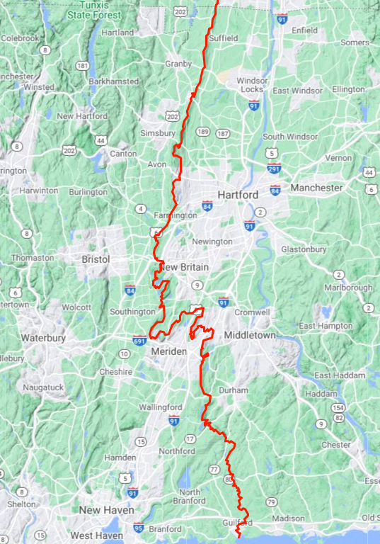
I recently took a private flying lesson from Brainard Airport in Hartford, climbing to the air along the Connecticut River. I had just completed the last of the 110 miles of the Connection portion of the New England Trail the day prior. Taking to the sky and getting a sweeping panorama of this thing called the Metacomet Ridge, having just walked every step of it, was an unexpected culmination of a goal I set around this time last year. I have been steadily knocking off the blue blaze trails around the state Nipmuck, Shenipsit, Narragansett, and felt it was finally time to tackle the New England Trail. I had originally envisioned this back in 2019 when I paddled down the Connecticut River and intended to immediately turn around and hiked back up to the Massachusetts border via the NET. That turned out to be a bit too audacious and I ended the trip after the paddle.

This ridge of rock and earth that runs along the west side of the Connecticut River was formed 200 million years ago. The ridge took 20 million years to form as a prehistoric rift valley deposited floods of lava with spans of erosion and build-up creating the layered basalt “traprock” we are familiar with today. Collectively, it is such a dominant feature of the landscape, but rarely do we think about it at this scale. We might be familiar with its iconic locations at West Rock, Sleeping Giant, or Talcott Mountain or an area like the Hanging Hills, or “that ridge you drive alongside” on your way to work. These locations have been notable even to the Native Americans who lived in the nearby river valleys. Many of the ridges still bear their names Besek, Pistapaug, Metacomet.
You can trace the idea for this trail all the way back to 1919 when then Head of the State Park Commission purchased Black Pond as a wayside park and a “waystation on the Trap Rock Trail”. I don’t know their full vision for what this ‘Trap Rock Trail’ would be, but it isn’t hard to imagine that they pictured a path traversing this dominant feature. The cause was taken up by the fledging Trails Crew of the Connecticut Forest and Park Association with main sections of the Mattabesett and Metacomet which were developed from the late 1930s to the early 1950s. The trail has slowly connected over the years with reroutes here and there. It’s fun to read the old trail guides, “turn north at the Puritan lunch room” and hear the old names for familiar places like Washington Head, Panther Swamp, and Chimney Point.
The two trails were fairly complete by 1970 but it wasn’t until 2009 that the last stretch was realized towards Long Island Sound. The federal government under President Obama declared the trail a National Scenic Trail on March 30, 2009 as part of Public Law 111-11 (Section 5202) to place it at the same level as the better known Appalachian and Pacific Crest Trails. It was then known as the MMM Trail (Mattabesett, Metacomet, and Monadnock Trail systems) and highlighted the scenic qualities of classic New England.

As of 2024, we are now 15 years into this thing as nationally recognized and close to 100 into its development. A final 4 mile stretch has been added to south Chittenden Park so that the trail can officially reach Long Island Sound and we’ve gained a notch or two on thru-hiking opportunities. But, there is still a long way to go. There are only four legitimate camping areas on the trail and only one in the last 65 miles. Water sources are surprisingly few and far between since the trail travels ridge top for much of the way, about three road walks that you’d really prefer to avoid, and just general awareness – most people have heard of the Appalachian Trail, but were you familiar with the extent of the NET? Did you know that the Connecticut portion isn’t even half its length? There is still another 125 miles north to Mt. Monadnock in New Hampshire!
The New England Trail is a journey through Connecticut’s heart, where history, geology, and countless views converge. Every step traces the old stories etched into the land of history, geology, and colonial landmarks and creates new ones with the thousands of visitors to their favorite sections each year. These traprock ridges, shaped over millions of years, stand as familiar and enduring marks on our landscape connecting iconic landmarks like Talcott Mountain and lesser-known gems waiting to be discovered anew. The trail is an invitation to experience the state in a way few do, step by step along its ancient spine.
As I gazed down from the cockpit of that small plane over the same ridges I had just hiked, I was struck by the intertwining of my personal hike with the history of our land in one collective swoop. Consider tackling a short local stretch or set your sights on the state’s 110 miles, heck even the full 235, the New England Trail offers an opportunity to connect with Connecticut’s landscape, interact with the old stories, and to create new ones.
The New England Trail deserves its place in the spotlight—and more importantly, it deserves to be experienced. The ridges are calling, so get out and explore!
