
Mattabesett Trail Guide
Trail at a Glance
The Mattabesett Trail is one of Connecticut’s blue blaze trails maintained by the Connecticut Forest and Park Association.
It runs 64 miles in a V-shape from Middletown south to Guilford and then north to Berlin.
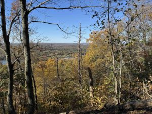
The trail is filled with remote vistas, traprock on the Metacomet Ridge, water views, and other highlights.
It is also part of the 235 mile New England National Scenic Trail (NET) with connections to the Menunkatuck Trail to the south and the Metacomet Trail to the north.
Currently I have only hiked portions of the trail so this is an incomplete guide.
Fastest Known Time: Justin Kousky 14h11m17s on 2020-06-27

Highlights
Links
- CFPA Mattabesett Official Link
- New England Trail Official Link
- New England Trail ExploreCT Link
- CTMQ – Mattabesett Trail Intro
- Tangled Up in Blue (2020)
- Scott Livingston – New England Trail Mattabesett End to End (2020)
- Air Land Sea – Mattabesett Fastest Known Time (2019)
- Scenes from the Trail – Mattabesett (2019)
- McWilliams Takes A Hike – Mattabesett Trail (2016)
Section List
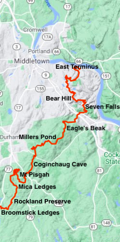
(East to West) Distances may be slightly off due to reroutes
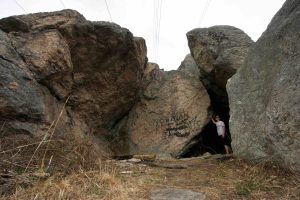
- Mattabesett East Terminus – 4.8 miles (Parking Link) – Rough trails to a rock pile cave at 3.4 miles and a connection to the Asylum Reservoir trails
- Bear Hill – 4.2 miles (North Parking) (South Parking) – Climb to the rocky summit amidst thick mountain laurel
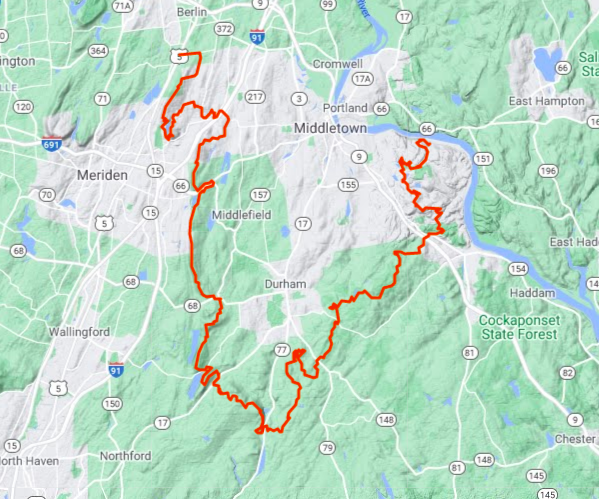
- Seven Falls – 1.5 miles – (Parking Link) – Recent reroute that makes the best of a utility corridor before passing the falls
- 1.9 mile road walk Nedobity Rd to Brainard Hill Rd
- Eagle’s Beak – 2.5 miles – (North Parking) (South Parking) – Unexplored
- 0.7 road walk Foot Hills Rd to Weise Albert Rd
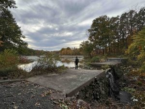
- Millers Pond State Park – 3.1 miles (North Parking) (South Parking) – Past Millers Pond to Bear Rock overlook
- Coginchaug Cave – 4.7 miles – (North Parking) – Unexplored, due to a reroute the trail no longer passes the cave and is a half mile side trail. This stretch now reaches all the way to Mt. Pisgah
- Mt. Pisgah – 1.5 miles – (Parking) – Unexplored
- Mica Ledges – 1 mile – (Parking) – Unexplored
- Rockland Preserve – 1.4 miles (Parking) – Rocky dense forest with some old forest roads
- Camping Area Godman Group Campsite
- Broomstick Ledges – 2.8 miles – (Bluff Head Parking) – Beautifully rocky winding trail over and between the ledges
- Junction with the Menunkatuck Trail
- Bluff Head – 3.9 miles (Parking) – Climb to overlook views before traveling through deep rolling woods
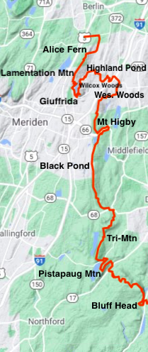
- 0.5 mile road walk Stagecoach Rd to Rt 17
- Pistapaug Mountain – 1.9 miles – Very long gradual climb to a nice viewpoint and an uneventful summit before a long rocky descent
- Tri-Mountain State Park – 4.1 miles (South Parking) – Climbing steeply again into this scenic reserve, a descent, and another very steep climb to a viewpoint
- Camping Area Cattails Shelter
- 0.2 mile road walk on Rt. 68
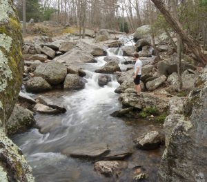
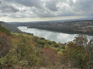
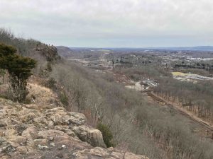
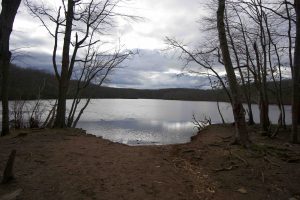
- Black Pond – 5.1 miles – (North Parking) (South Parking) – A long hike on the Beseck Mountain Ridge culminating in a cliff overlook of Black Pond
- Mt. Higby – 2 miles – (Parking Note: if you use the Higby Mountain Trail Head on Google Maps it will direct you to the Black Pond parking area) – Rugged hike with many great views
- Wesleyan Woods Conservation Area – 1.7 miles – (Parking) Down off the ridge on a long abandoned old woods road
- 1.2 mile road walk Country Club Rd over I-91 to Bell St
- CLOSED June 1st – Fall 2025 Highland Pond – 0.5 miles – Easy flat stretch with views of the pond and two short bridges
- 0.4 mile road walk on Atkins St.
- Wilcox Woods – 0.8 miles – (Parking) Pleasant walk through pines and beginning to climb into Giuffrida
- Giuffrida Park – 3.5 miles – Parking – A U shaped hike over Chauncey Peak, down to the reservoir and up towards the west ridge
- Lamentation Mtn State Park – 3.3 miles – (North Parking)
- Camping Area Lamentation Mtn Primitive Tentsite
- Alice Fern Bruce Preserve – Last of the ridge before descending to a mixed road and trail
- (North parking closed)
- 2.6 mile road walk to Metacomet Trail
The Mattabesett was the third trail created by the Connecticut Forest and Park Association and was completed in 1932. Students from Wesleyan University helped to clear and blaze the trail.
In 2009 it was added to the New England Trail
{{locationDetails}}
