
Explore Killingly, CT
Killingly at a Glance
Part of Windham County
If you’re looking for the best hiking trails in Killingly this is the complete guide to all the long trails, waterfalls, and history it has to offer.
Killingly protects nearly 1,800 acres of open space which hosts:
- 15 hiking areas with about 24 miles of trails
- 5 boating/fishing areas
- 1 archeaological preserve
My Highlights
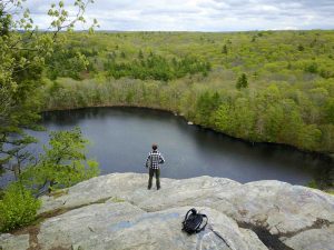
- Miles of trails, boating, rock climbing, and a great overlook at Old Furnace State Park
- The history of Lebeau Fishing Camp Archaeological Preserve
- Waterfall at Cat Hollow
- Hidden gem of a hike at Quandoc Conservation Area
Hiking
Town Parks
- 1892 Conservation Area –★★– 1.85 miles – (aka Sherman Forest) Overgrown on my last visit, confusing trails lead to an old foundation
- Cat Hollow –★★– 1 mile – Simple but popular spot with an old dam waterfall and history
- Chase Reservoir –★★– 2.5 miles – Mainly serves to protect the reservoir but overgrown trails lead to woods roads popular with dirt bikes
- Hygeia Reservoir – No trails? Swimming for town residents
- Mason Hill Conservation Area –★– 0.5 miles – Short overgrown loop on my last hike in 2022
- Owen Bell Park –★★– 1 mile – Great town park with multisport fields, pond, walking track, easy hiking trails, and playgrounds
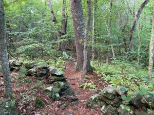
- Quandoc Conservation Area –★★★– 2.5 miles – Expanded trails roam this beautiful hilly area
Land Trust
- Wyndham Land Trust
- Dunn Preserve –★★– <1 mile – An old driveway down to the river next to a collapsed house
- Edward R. Laby Memorial Preserve –★– 1.3 miles – Dirt road to a trail down into the woods and back
- Yosemite Valley, Kogut, and Schneider Preserves – All preserved land, no trails
- Wolf Den Land Trust
- Sherman Memorial Forest –★★– 1.85 miles – Overgrown on my last visit, confusing trails lead to an old foundation
- Wyndham Land Trust
State Parks / Forest
- Killingly Pond State Park –★– <1 mile – Unfriendly to everything but boaters, there are short fisherman’s paths and old woods roads
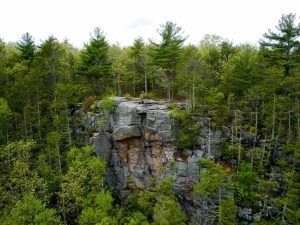
- Old Furnace State Park –★★★★– 3 miles – A choose your own adventure hike around ponds, upland forest, and dramatic cliff views
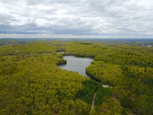
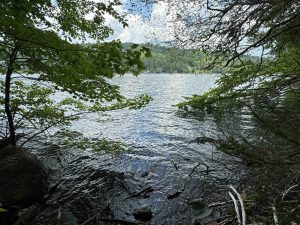
- Quinebaug Lake State Park –★★– 2 miles – Simple yet beautiful loop hike around the lake
- Ross Pond State Park and Ross Marsh WMA –★★– 1.5 miles – Connected to Old Furnace State Park for extended trail hikes
- Snake Meadows WMA – No trails, located on the northeast side of Tetreault Pond
Blue Blaze
- None
The Rest
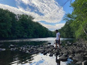
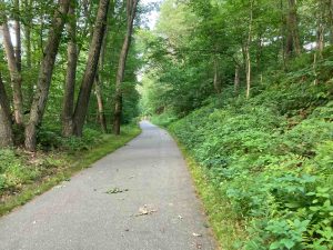
- Quinebaug River Trail –★★– 3.1 miles – Paved rails to trails with access to the Quinebaug River and the Lebeau Fishing Camp archaeological preserve
- North-South Trail section –★– 1 mile – Dirt roads that briefly clip into Connecticut, the rest of the trail is in Rhode Island
Boating/Fishing
- Killingly Pond State Park
- Quinebaug Lake State Park
- Quinebaug River
- Boat launch off Rt. 101 (Parking Link)
- Boat launch at Quinebaug River Trail
- Chase Reservoir
- Black Pond Brews – Wednesday-Sunday 12-9pm
- Chubby Dog Coffee Gaming Bar
- Logee’s Greenhouses – Wednesday-Sunday 10-4:30pm Fancy botanicals and exotic plants
- Sugarz Bakery – 7 days a week check hours
The land of Killingly was within the lands of the Quinebaug people and was river area was known by many including the Nipmucks, Pequots, Mohegans, and Narragansetts as an important fishing place, calling it “Acquiunk”. There was also a fort on a low hill in the Danielson area. East Killingly was known as “Chemaug”.
The land was settled by as early as 1693 by a man named Richard Evans and about 200 acres was secured by a Reverend Noadiah Russel who then sold to Peter Aspinwall. There is also the story of Joseph Leavens, a young man, was bitten on the thumb by a rattlesnake. He saved his own life by chopping off the bitten thumb with his axe and then killing the snake. In the years afterward the Native American’s gave him the nickname ” Old One-thumb.”
James Danielson of Block Island had served in the Narragansett War purchased 2000 acres between the Quinebaug and Five Mile Rivers from Major James Fitch for 170 pounds in 1707. An early name for Killingly was Aspinock apparently from the word “aucks” (the place where) and the name of an early English settler, Lieutenant Peter Aspinwall (who lived only about a mile south of modern day Putnam).
Killingly became the 42nd town established in Connecticut when it was formally incorporated in 1708 by the Connecticut’s General Assembly.
“Northerly on the line of the Massachusetts Province (it being by estimation about) five miles from the line between this Colony and the Colony of Rhode Island and the river called Assawaug; easterly on the said line between the said colonies; southerly, partly on the northern boundary of Plainfield and partly on a line to be continued east from the northeast corner bounds of Plainfield to the said line between the said Colonies; the said northern boundary of Plainfield being settled by order of the General Court, May the 11th, 1699, and westerly on the aforesaid river; the said township being by estimation about eight or nine miles in length and five or six miles in breadth, be the same more or less.”
In 1831 the iron furnace for Old Furnace State was built. By 1836, Killingly was the largest producer of cotton goods in Connecticut thanks to textile mills along the Quinebaug and Five Mile Rivers. In 1840 the Norwich & Worcester Railroad opened and population began to center around it. John Day (the name for Dayville), a well-to-do farmer with interests in real estate, built the Sayles Mill in 1846. Dayville became an industrial hub In the 1920s the firm of Powdrell & Alexander operated six curtain factories in town leading to the name “Curtaintown USA”. The Great Depression ended textile production in Killingly, but some were later bought to build and produce other goods.
Further Reading:
- https://www.killinglyhistorical.org/museum/killinglys-villages
- https://connecticutgenealogy.com/windham/proprietors_of_killingly.htm
{{locationDetails}}
