
Explore Ashford, CT
Ashford at a Glance
Part of Windham County
If you’re looking for the best hiking trails in Ashford this is the complete guide to all the long trails, waterfalls, and history it has to offer.
Ashford has a total of 17 hikes for 39.5 miles of trails, but unfortunately not much for fishing or boating opportunities.
My Highlights
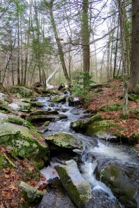
- The hiking and camping around Pixie Falls
- The rugged terrain of Boston Hollow
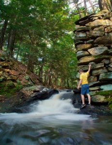
- The bridge ruins at Tinkerville Brook
Hiking
Town Parks
- Ashford Memorial Park –★★– 1.3 miles – Simple loop hike along the Mt. Hope and walking track
- Langhammer Trail –★★– 1.2 miles – A short loop hike through the forest with a connection to Willington’s Ruby-Fenton Park
Land Trust
- Joshua’s Trust
- Ashford Oak –★– No trails – A shell of its former glory, the former champion red oak is living out its remaining days
- Church Farm –★★– 3 miles – A loop ‘Ledges’ trail on one side of Rt 89 and a ‘Meadows’ trail on the other
- Fliegal Farm Woods –★– .5 miles – A short Fern Glade lollipop loop trail along the Old Connecticut Path
- Friedman Forest –★★– 2.7 miles – A self guided tree identification walk with three loop options and a heron rookery
- Iron Mine Valley –★★– 1.3 miles – An area mined for bog iron during the Revolutionary War with a short loop hike
- Josias Byles Sanctuary –★★– 1.6 miles – A loop hike with a view of the marsh along the Mt Hope River at the site of one of Ashford’s original homesteads
- Knowlton Hill Preserve –★★– 2.5 miles – From the serene hillside of a glacial drumlin explore 2.5 miles of trails passing the Knowlton Estate and local history on a self-guided hike
- Rankin Preserve –★★– 1.5 miles – One of Joshua’s Trust’s newest trails past linked ponds to a loop through rocky ledges and sloping forest
- Tinkerville Brook –★★– 1.2 miles – A hidden gem this loop hike passes the ruins of an old bridge along a brook named for the gypsies that camped along it
- Joshua’s Trust
State Parks / Forest
- Natchaug State Forest
- West Ashford Block – 1.2 miles – After crossing Rt. 74 enter designated “old forest” with steep slopes and dense mountain laurel
- Perry Hill – 2.3 miles – Gradual terrain passes through land rebounding from a timber harvest
- Pixie Falls – 2.1 miles – This section of the Nipmuck features old foundations, Pixie Falls, a stretch of the 400 year old Old Connecticut Path, and Ladies Room Rock
- Natchaug State Forest
Blue Blaze – Nipmuck and Natchaug in Ashford
- Natchaug Trail
- Natchaug: Lyon Rd –8 miles – A long secluded stretch along Bigelow Brook from Eastford into Ashford until the Natchaug’s north terminus
- Natchaug: Lyon Rd –8 miles – A long secluded stretch along Bigelow Brook from Eastford into Ashford until the Natchaug’s north terminus
- Nipmuck Trail
- Marsh Road – 2.7 miles – Rerouted in 2017 this long stretch passes the backside of a farm to meet old roads and Knowlton Brook before crossing Rt. 74
- Natchaug State Forest: West Ashford Block – 1.2 miles – After crossing Rt. 74 enter designated “old forest” with steep slopes and dense mountain laurel
- Natchaug State Forest: Perry Hill – 2.3 miles – Gradual terrain passes through land rebounding from a timber harvest
- Turn right for a 0.7 mile road walk along Oakes Rd, cross Rt. 89 diagonally and head 0.2 miles down Iron Mine Ln
- Pixie Falls – 2.1 miles – This section features old foundations, Pixie Falls, a stretch of the 400 year old Old Connecticut Path, and Ladies Room Rock
- Camping Area just past Pixie Falls
- Yale Forest: Eastford Road – 1.6 miles – A largely forgettable section that passes along a small ridge through alternating mountain laurel and open forest
- Yale Forest: Boston Hollow – 4.2 miles – The most rugged stretch of the entire trail with a steep climb to a narrow vista then dense laurel, hills, and valleys
- 0.1 mile road walk along Barlow Mill Rd
- Yale Forest: Walker Mountain – 1.9 miles – This section heads up and up and up with a new spur trail to the Walker Mountain summit and then down through the Yale Forestry school
- Natchaug Trail
The Rest
- Yale Forest
- Eastford Road – 1.6 miles – A largely forgettable section of the Nipmuck Trail that passes along a small ridge through alternating mountain laurel and open forest
- Boston Hollow – 4.2 miles – The most rugged stretch of the Nipmuck with a steep climb to a narrow vista then dense laurel, hills, and valleys
- Walker Mountain – 1.9 miles – Nipmuck Trail section heads up and up and up with a new spur trail to the Walker Mountain summit and then down through the Yale Forestry school
- Yale Forest
Boating/Fishing
Not much for boating unless you have private access but fishing at:
- Mt. Hope River at Ashford Memorial Park
- Ashford Lake
Ashford was first settled in 1710 and was quickly incorporated as town in October 1714 making it the 44th oldest town in Connecticut. The name is likely named after Ashford in Kent, England.
President George Washington passed through the town on November 7th 1789 after stopping in Pomfret intending to see Israel Putnam. He involuntarily stayed the night in town when the villagers proclaimed it was against the law to travel/hire a carriage on a Sunday. Read his diary entry here.
{{locationDetails}}
