
Photos


Description
Sprague Land Preserve
Location: 691 acres in Franklin and Sprague, CT
Parking:
- Watson Section Parking: Medium sized lot near the end of Holton Rd North Franklin, CT
- Mukluk Section Parking: Small lot down the long gravel road near 46 Holton Rd North Franklin, CT
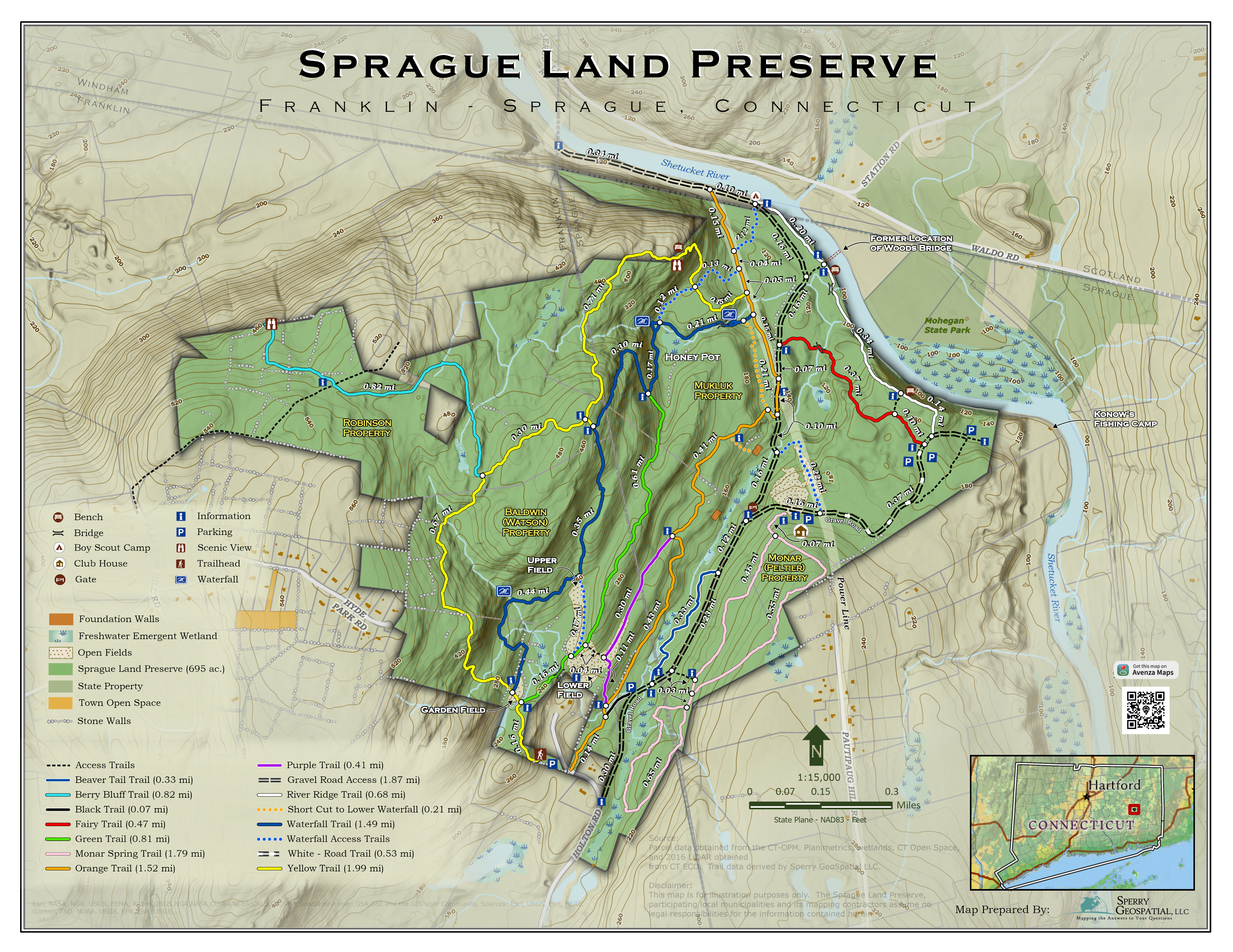
Trail Map Trails: 11 miles Rating: ★★★★☆
![]()
- Known as the Waterfall Trail the map is marked with a seasonal waterfall, but there are actually four along its length each with its own shape and character. It can easily be accessed from either parking area. The entire trail is hilly though not quite the extreme climbs of the yellow trail. From the Watson Section parking follow the yellow trail until you reach a small field and a sign will direct you to the right. A quarter mile later is the first waterfall (marked on the map) a wide flowing cascade shown in the first photo. 0.6 miles and few hills later is a connector to the yellow trail and 0.4 beyond that is a connector to the green trail. The second waterfall is a wild jumble of rocks accessed by following a stonewall heading off to the left. Immediately after the waterfall the trail turns into the Blue Dot, but you’ll want to take a hard right turn to follow the water downstream to the third waterfall .1 miles downhill. The blue trail empties into the utility corridor which can be taken left to the Shetucket or right to the Mukluk parking.
- The yellow trail is a long steep climb to the ridge of the Watson property out to an overlook. Starting from the Watson Section Parking the trail heads uphill for a tenth of a mile until reaching a small field. This area is extremely wet after rains but stones, logs, and a grate have been placed to help you across. The trail then heads steeply uphill for a third of a mile until reaching the hilly ridge. Entirely forested, the trail winds through rock formations and the over the occasional stream. There is a connector trail down to the Blue Trail at 1.1 miles and a stream that may require a careful log crossing at 1.3 miles. At 1.75 miles you will descend to the bench overlook with a great eastern view. Immediately past the overlook the trail takes a very steep descent that may require scrambling for some. The trail connects to the blue dot trail and beyond that another descent to the Orange open utility corridor which can be taken left to the Shetucket or right to the Mukluk parking.
- Starting as the gravel access road to the Mukluk parking that is rutted packed earth that you’ll have to share with cars until you’re past the old Mukluk clubhouse. However, the trail does turn off into the pines along the high banks of the Shetucket River. This section is known as the River Ridge Trail and was put in by as an Eagle Scout Project by Phillip Silva complete with well-built bridges. Short and Medium loop options have been added for those coming from the Mukluk parking. There is also now a sign noting the remains of Waldo’s Bridge which historically crossed the Shetucket but was washed away and never rebuilt. The trail rejoins the gravel road at the north end of the preserve and continues to the Shetucket River dam. The dam falls outside the boundary of the preserve, but a nice sign thanks you for visiting and welcomes you back. The dam is hydroelectric and occasionally releases water (see boating section).
- On my spring 2022 visit I found the fairy trail has either expanded or I missed the second part on all my previous visits so I doubt the 0.6 mile distance is accurate. This red blazed ‘Fairy Trail’ is dotted its entire length with fairy houses, wood sculptures, and hidden constructions. While many people I’ve hiked with have been skeptical at first, they come around thanks to the creativity and uniqueness.
- I’ve done the section by the beaver overlook along the stream here and while it does connect to the Watson Section Parking it doesn’t seem to connect to the Blue or Purple Trails though I certainly may have missed it.
- I haven’t really explored these on any of my hikes, often because they don’t connect where I expect them to and don’t have much for interesting sights along them.
“Work with property owners, State, Friends of Shetucket, and others to acquire additional open space parcels and/or conservation easements along the Shetucket River with the goal to create a trail from Baltic Village to the Sprague Land Preserve that includes handicapped access, exercise equipment, art, education, parking, and river access.”
In January 2022, the Sprague Land Preserve was expanded with the purchase of the 66.36 acre Monar/Peltier property near the Mukluk section through which they aim to add another trail!
History:
The original 270 Mukluk Preserve was purchased in 2005. The 230-acre Watson Farm property was purchased in 2012 and the 125-acre Robinson property was added in 2016. The 66 acre Monar/Peltier property was added in 2022.
The property has been used for many things since the early 1700’s and was owned by the town’s namesake – William Sprague. Near the second bridge on the white trail, is a crossing known as “Waldo’s Bridge” (across the river in Scotland is the Edward Waldo house) which once provided the most direct route for stagecoaches to reach Norwich from the west side of the river. The bridge abutments, as well as the foundations of homes and old tavern, still exist though are difficult to spot.
Links:
TrailForks – Mountain Biking Sprague Land Preserve
Peter Marteka – A beautiful eastern Connecticut preserve in Sprague grows bigger (2020)
Peter Marteka – Sprague Offers One Of Largest Preserves In Southeast Connecticut (2010)
Peter Marteka – The Scenery Is Just The Beginning Of This ‘So Special’ Gem (2009)
Town of Sprague – Ride the Shetucket River
Town of Sprague – 2018 Plan of Conservation and Development
Tiffany Young @ the Outbound
Lois Bruinooge @ The Last Green Valley
The information shown here is for general reference purposes only. exploreCT.org gives no warranty, expressed or implied, as to the accuracy or reliability of this data. Parking in all areas, whether designated here or not, is at your own risk. exploreCT.org is not responsible for any damage or loss to vehicles or contents.
Last updated May 22nd, 2022
Video
Visited 18067 times, 2 Visits today


