Site logo
    • Explore
      • Blue-Blaze Trails
      • Land Trusts
      • State Parks and Forests
      • By Town
    • exploreCT+
      • Membership
      • Shop
      • Events
    • Blog
    • Town Guides
    Sign in or Register
    Listing cover image

    Zemko Sawmill Preserve

    • Trails
      2 miles
    • Rating
      ★★☆☆☆
    • Address
      229 Rattlesnake Ledge Rd, Salem, CT 06420, USA
    • Explore
    • Trail Map
    • Reviews 0
    • New Page
    • prev
    • next
    • Bookmark
    • Share
    • Get directions
    • Report
    • prev
    • next
    At A Glance

    Salem Land Trust

    92 acres in Salem, CT

    Parking: Small lot near 180 Rattlesnake Ledge Rd, Salem, CT

    Trail Map        Trails: 2.2 miles        Rating: ★★☆☆☆

    Hiking

    I visited once in January of 2017 and didn’t take any photos, so this write-up is a pretty foggy recollection.  I hope to update it soon.

    From the small parking area an old woods road heads back to a large clearing that must have been the site of the Zemko family sawmill.  Peter Marteka saw the sawmill’s walls and buildings had been pushed to the bog on his 2010 visit to the preserve, but they are either gone or I missed them on my visit.

    Just uphill from the clearing are the chestnut plantings which had a large signboard explaining the project.  I then followed the red trail all the way to the end. At the time the white trail was a spur that only connected to the red trail at the north end.

    I took the orange trail back and remember it as a series of hills and valleys but not much to note.

    In 2016 the Salem Land Trust received an additional 20 acres next to the property and put in trails later in 2017/2018 so I haven’t yet explored those.

    History

    The land trust purchased the property from Charles and Karen Zemko in 2009 for $230,000

    Links

    Peter Marteka – The Zemko Sawmill Preserve Offers A Step Back In Time (2010)

    Tags
    • ★★☆☆☆
    • 2017
    • Explored
    • New London County
    • Peter Marteka
    • Salem
    • Salem Land Trust
    Last Updated

    The information shown here is for general reference purposes only. exploreCT.org gives no warranty, expressed or implied, as to the accuracy or reliability of this data. Parking in all areas, whether designated here or not, is at your own risk. exploreCT.org is not responsible for any damage or loss to vehicles or contents. Last updated January 17th, 2017

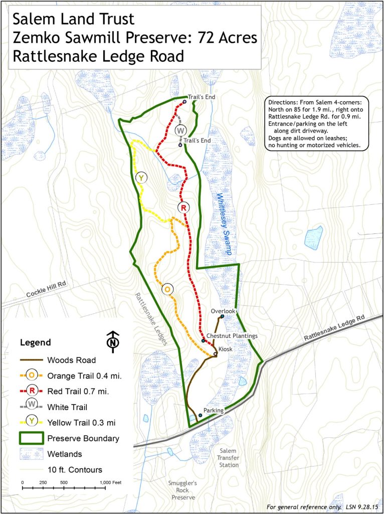
    Trail Map
    Location
    • 229 Rattlesnake Ledge Rd, Salem, CT 06420, USA

      Get Directions
    Categories
    • Hiking
    Gallery
  • No comments yet.
  • Add a review

    Leave a Reply · Cancel reply

    You must be logged in to post a comment.

    You May Also Be Interested In

    Spruce Brook Falls

    • ★★★★★
    • 16 miles
    Featured
    FW6F+CW Beacon Falls
    • Quick view
    • Bookmark

    White Oak Preserve

    • Unexplored
    • 0.2 miles
    600 Raymond Hill Rd
    • Quick view
    • Bookmark

    Woodlands Nature Preserve

    • Unexplored
    • 0.5 miles
    99 Beacon Hill Dr
    • Quick view
    • Bookmark

    Hi, I’m Matt.

    I’m building ExploreCT to be the guide for all your outdoor adventures. All the trails, views, and waterways this great state has to offer.

    Now get out and explore!

    Monthly Newsletter

    Each month I share site updates or an interesting article in my newsletter. It’s short, sweet, and practical.

    600+ explorers read it, I’d love for you to join.

    Thank you!

    You have successfully joined our subscriber list.

    X-twitter Youtube Envelope Instagram

    Cart

      • Facebook
      • X
      • WhatsApp
      • Telegram
      • LinkedIn
      • Tumblr
      • Reddit
      • VKontakte
      • Mail
      • Copy link
      • Share via...
      • Threads
      • Bluesky