Old Hibbert Property

298 Old Colchester Rd, Amston, CT, USA

Website

★★☆☆☆

Old Hibbert Property

Hebron Town Park

66 acres in Hebron, CT

Parking: Shoulder parking near 298 Old Colchester Rd, Amston, CT

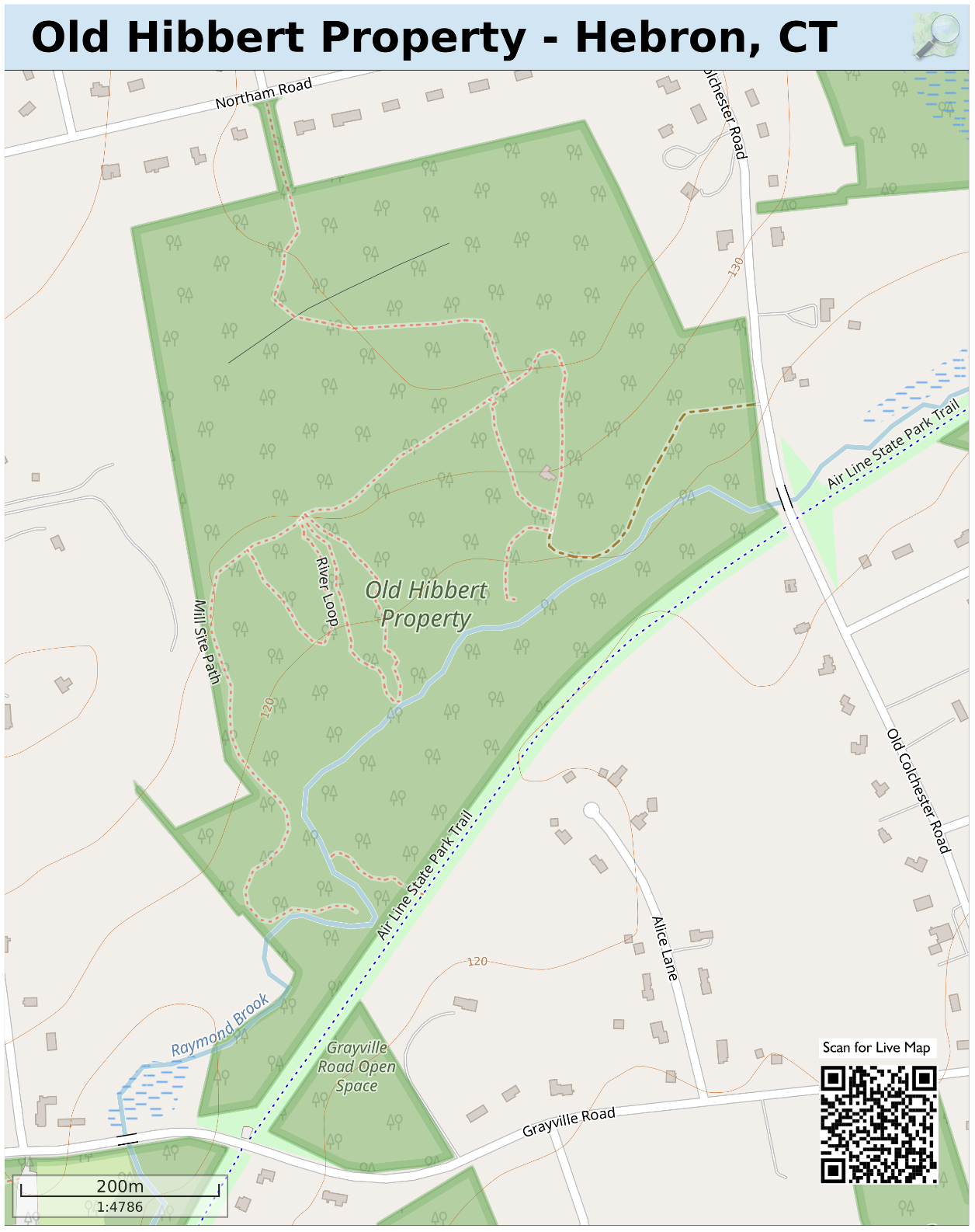
Trail Map         Trails: 1.3 miles      Rating: ★★☆☆☆


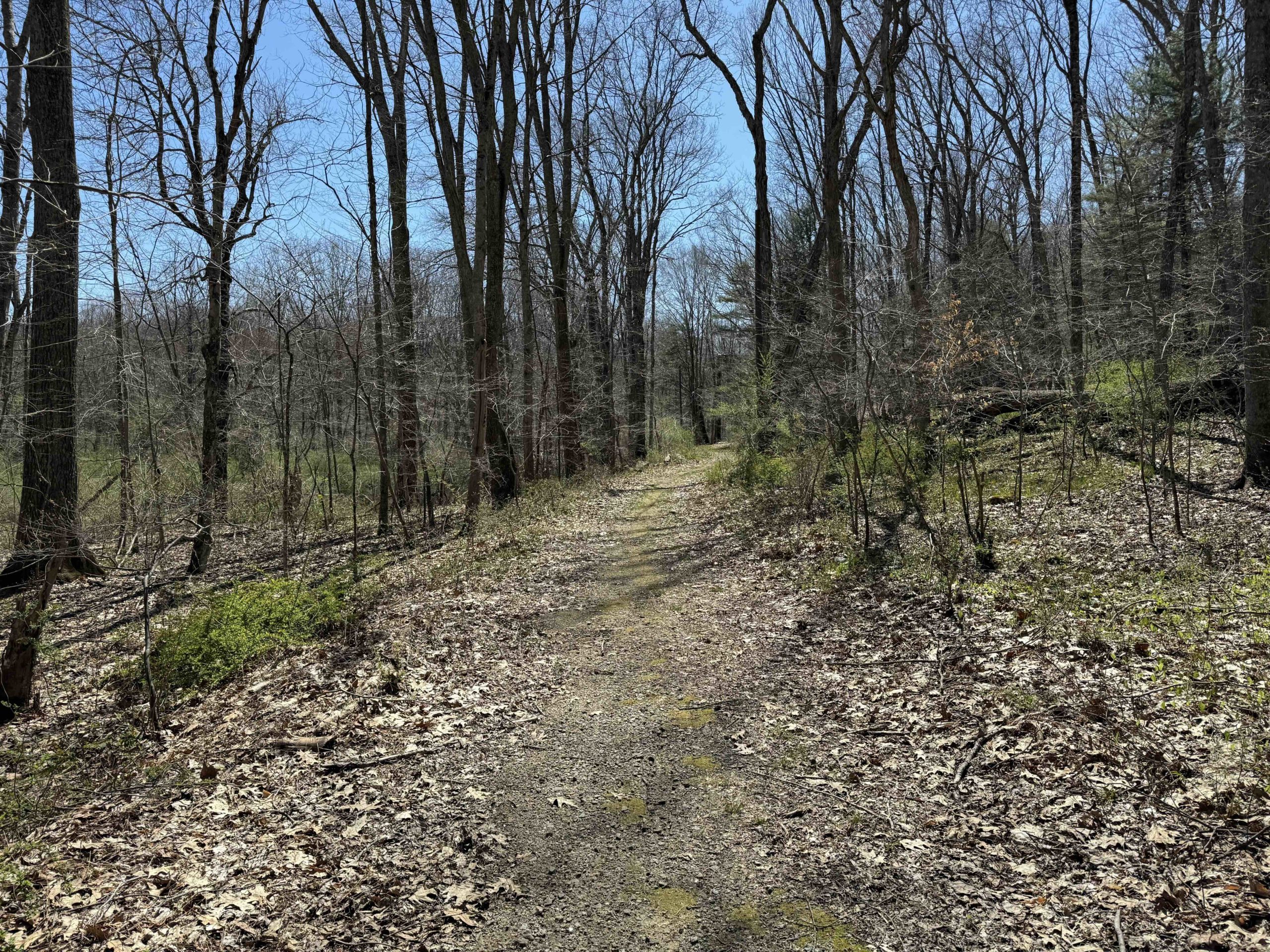
The Old Hibbert Property is a town open space with some short hiking trails and the possibility for more.  I parked on the shoulder of Old Colchester Road at the chained entrance to the property.  The entrance trail is surely the properties former driveway which climbs wide and gradually up into the woods with occasional views of Raymond Brook off to the left.  After a curve in the trail it opens to what surely was the former site of a house on the property with a two large clearings, rings of daffodils, and old detritus from the properties former life.

I followed the blue trail up past the clearing, the trail was no longer a wide driveway and instead a narrow but well-traveled trail, passing an old desk chair and a crutch hanging from a tree. I skipped the other entrance trail the winds along a stone wall to reach Northam Road between private property, so I can’t confirm if that works as a secondary parking spot or just community access.

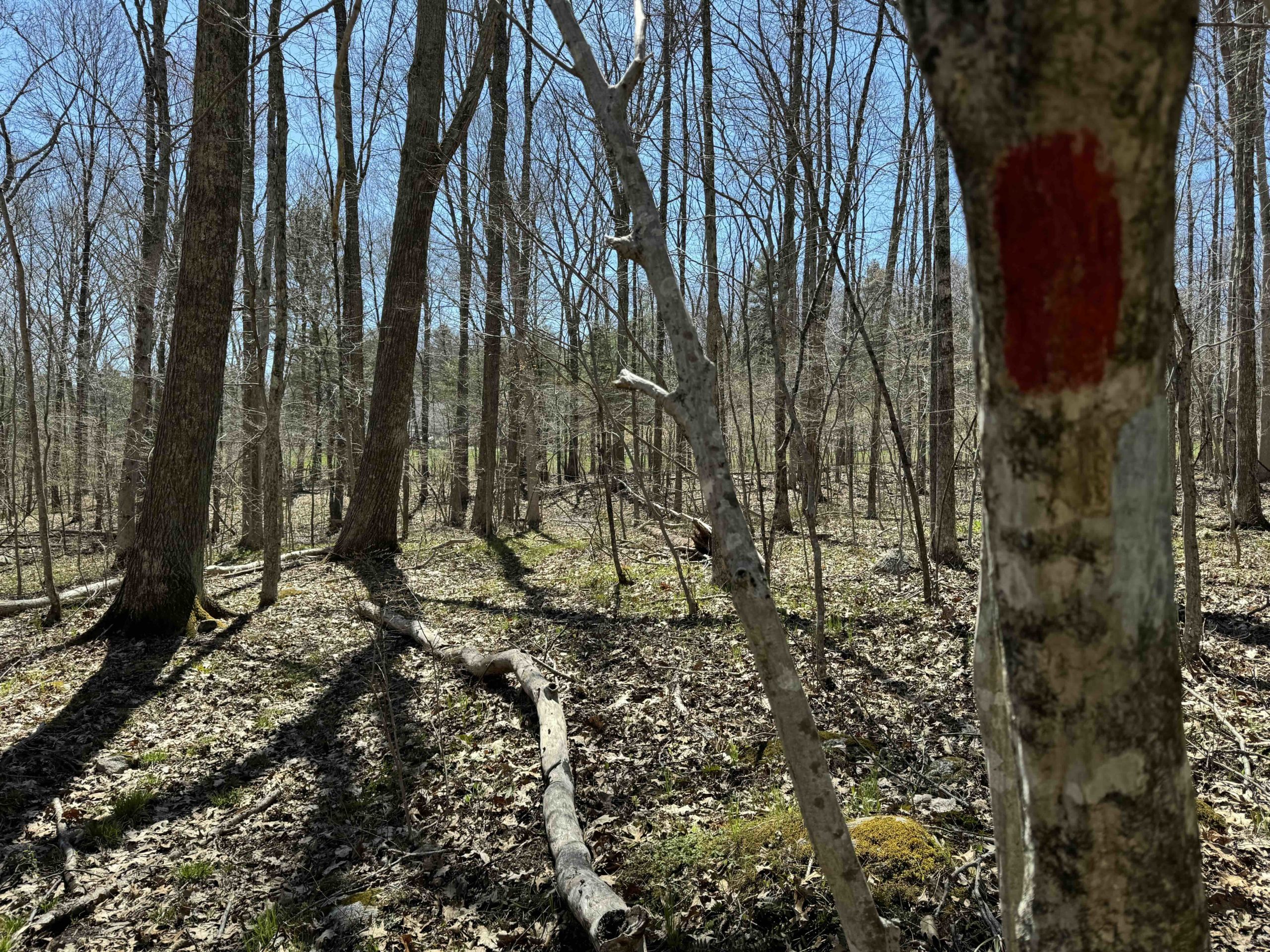
Blazes switched to blue white and the trail returned to a more old woods road style heading downhill.  As the hill bottomed out so did the trail.  I was able to follow a couple yellow blazes which I guess are the start of the ‘Mill Site Path’, but turned around at a flooded section.  I then spotted red blazes, likely the ‘River Path’ and was able to follow the blazes and a faint trail, but I was likely the first person to hike the short loop in quite some time.

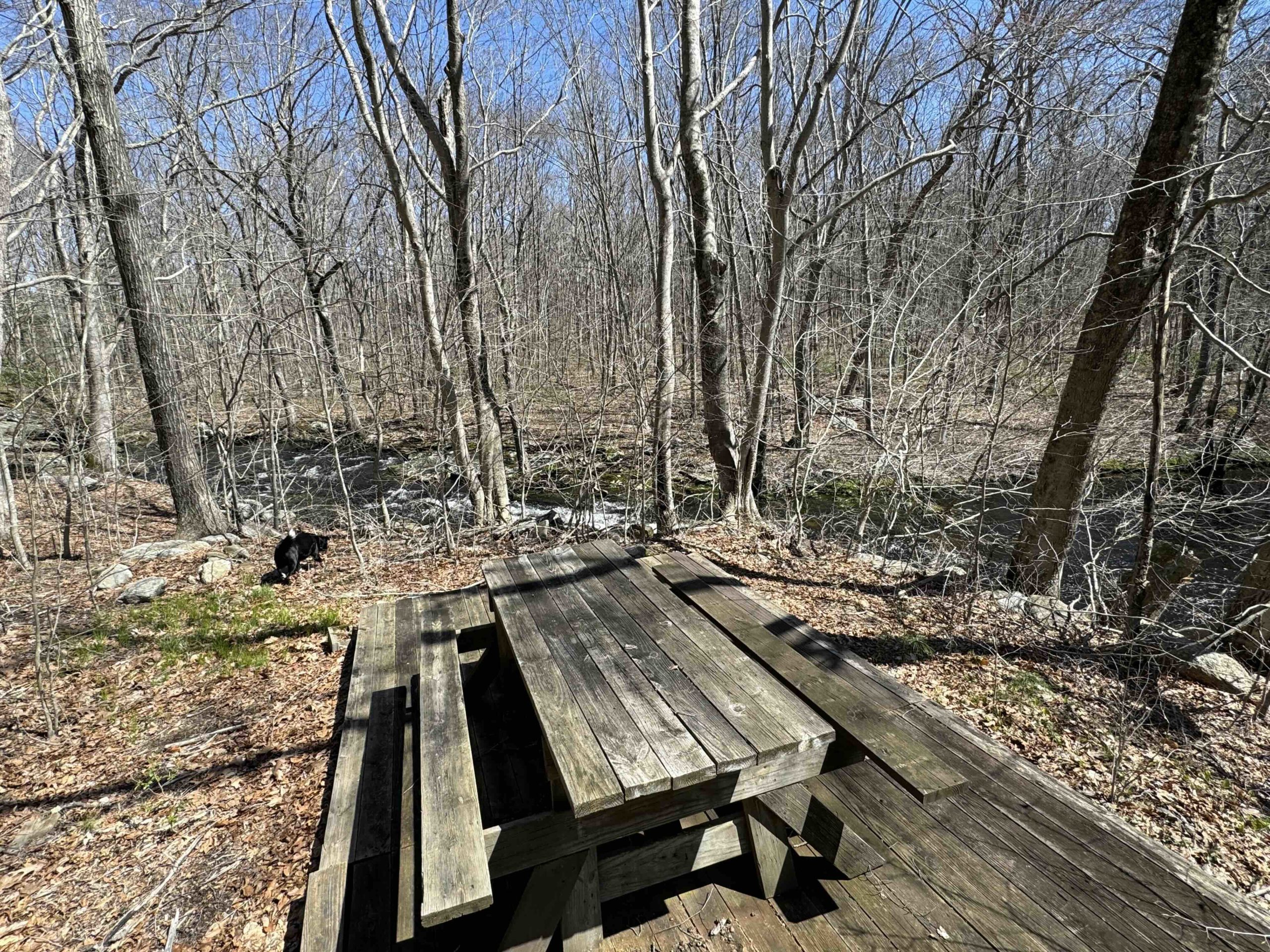
I returned the way I came, went past the house site and entered the lower clearing to find a wood platform, picnic table, and a great view of Raymond Brook.  There are rocky cascades, an enormous boulder, and a wide pool that may have once been a nice swimming hole.

In all, trails certainly exist here though likely only the short main loop is used by locals coming from Northam Road and the rest have been a bit forgotten.  I may reattempt the Mill Site Path in the winter, though I’m sure it’s just as easily viewed from the Air Line Trail which shares the southern border of the property.

History:

The property was purchased by the Town of Hebron from Donald Hibbert in 2018 for $390,000.


Links:

The information shown here is for general reference purposes only. exploreCT.org gives no warranty, expressed or implied, as to the accuracy or reliability of this data. Parking in all areas, whether designated here or not, is at your own risk. exploreCT.org is not responsible for any damage or loss to vehicles or contents.
Last updated April 22nd, 2024

Visited 417 times, 2 Visits today
Posted in Town Parks

Related Listings

Hebron Center Trail

★☆☆☆☆

41.663975, -72.362267

Old Hibbert Property

Hebron Town Park

66 acres in Hebron, CT

Parking: Shoulder parking near 298 Old Colchester Rd, Amston, CT

Trail Map         Trails: 1.3 miles      Rating: ★★☆☆☆


The Old Hibbert Property is a town open space with some short hiking trails and the possibility for more.  I parked on the shoulder of Old Colchester Road at the chained entrance to the property.  The entrance trail is surely the properties former driveway which climbs wide and gradually up into the woods with occasional views of Raymond Brook off to the left.  After a curve in the trail it opens to what surely was the former site of a house on the property with a two large clearings, rings of daffodils, and old detritus from the properties former life.

I followed the blue trail up past the clearing, the trail was no longer a wide driveway and instead a narrow but well-traveled trail, passing an old desk chair and a crutch hanging from a tree. I skipped the other entrance trail the winds along a stone wall to reach Northam Road between private property, so I can’t confirm if that works as a secondary parking spot or just community access.

Blazes switched to blue white and the trail returned to a more old woods road style heading downhill.  As the hill bottomed out so did the trail.  I was able to follow a couple yellow blazes which I guess are the start of the ‘Mill Site Path’, but turned around at a flooded section.  I then spotted red blazes, likely the ‘River Path’ and was able to follow the blazes and a faint trail, but I was likely the first person to hike the short loop in quite some time.

I returned the way I came, went past the house site and entered the lower clearing to find a wood platform, picnic table, and a great view of Raymond Brook.  There are rocky cascades, an enormous boulder, and a wide pool that may have once been a nice swimming hole.

In all, trails certainly exist here though likely only the short main loop is used by locals coming from Northam Road and the rest have been a bit forgotten.  I may reattempt the Mill Site Path in the winter, though I’m sure it’s just as easily viewed from the Air Line Trail which shares the southern border of the property.

History:

The property was purchased by the Town of Hebron from Donald Hibbert in 2018 for $390,000.


Links:

The information shown here is for general reference purposes only. exploreCT.org gives no warranty, expressed or implied, as to the accuracy or reliability of this data. Parking in all areas, whether designated here or not, is at your own risk. exploreCT.org is not responsible for any damage or loss to vehicles or contents.
Last updated April 22nd, 2024

Wilton Town Forest

Unexplored

162 Branch Brook Rd, Wilton, CT, USA

Old Hibbert Property

Hebron Town Park

66 acres in Hebron, CT

Parking: Shoulder parking near 298 Old Colchester Rd, Amston, CT

Trail Map         Trails: 1.3 miles      Rating: ★★☆☆☆


The Old Hibbert Property is a town open space with some short hiking trails and the possibility for more.  I parked on the shoulder of Old Colchester Road at the chained entrance to the property.  The entrance trail is surely the properties former driveway which climbs wide and gradually up into the woods with occasional views of Raymond Brook off to the left.  After a curve in the trail it opens to what surely was the former site of a house on the property with a two large clearings, rings of daffodils, and old detritus from the properties former life.

I followed the blue trail up past the clearing, the trail was no longer a wide driveway and instead a narrow but well-traveled trail, passing an old desk chair and a crutch hanging from a tree. I skipped the other entrance trail the winds along a stone wall to reach Northam Road between private property, so I can’t confirm if that works as a secondary parking spot or just community access.

Blazes switched to blue white and the trail returned to a more old woods road style heading downhill.  As the hill bottomed out so did the trail.  I was able to follow a couple yellow blazes which I guess are the start of the ‘Mill Site Path’, but turned around at a flooded section.  I then spotted red blazes, likely the ‘River Path’ and was able to follow the blazes and a faint trail, but I was likely the first person to hike the short loop in quite some time.

I returned the way I came, went past the house site and entered the lower clearing to find a wood platform, picnic table, and a great view of Raymond Brook.  There are rocky cascades, an enormous boulder, and a wide pool that may have once been a nice swimming hole.

In all, trails certainly exist here though likely only the short main loop is used by locals coming from Northam Road and the rest have been a bit forgotten.  I may reattempt the Mill Site Path in the winter, though I’m sure it’s just as easily viewed from the Air Line Trail which shares the southern border of the property.

History:

The property was purchased by the Town of Hebron from Donald Hibbert in 2018 for $390,000.


Links:

The information shown here is for general reference purposes only. exploreCT.org gives no warranty, expressed or implied, as to the accuracy or reliability of this data. Parking in all areas, whether designated here or not, is at your own risk. exploreCT.org is not responsible for any damage or loss to vehicles or contents.
Last updated April 22nd, 2024

Roaring Brook Park

★★★☆☆

827 Roaring Brook Rd, Cheshire, CT, USA

Old Hibbert Property

Hebron Town Park

66 acres in Hebron, CT

Parking: Shoulder parking near 298 Old Colchester Rd, Amston, CT

Trail Map         Trails: 1.3 miles      Rating: ★★☆☆☆


The Old Hibbert Property is a town open space with some short hiking trails and the possibility for more.  I parked on the shoulder of Old Colchester Road at the chained entrance to the property.  The entrance trail is surely the properties former driveway which climbs wide and gradually up into the woods with occasional views of Raymond Brook off to the left.  After a curve in the trail it opens to what surely was the former site of a house on the property with a two large clearings, rings of daffodils, and old detritus from the properties former life.

I followed the blue trail up past the clearing, the trail was no longer a wide driveway and instead a narrow but well-traveled trail, passing an old desk chair and a crutch hanging from a tree. I skipped the other entrance trail the winds along a stone wall to reach Northam Road between private property, so I can’t confirm if that works as a secondary parking spot or just community access.

Blazes switched to blue white and the trail returned to a more old woods road style heading downhill.  As the hill bottomed out so did the trail.  I was able to follow a couple yellow blazes which I guess are the start of the ‘Mill Site Path’, but turned around at a flooded section.  I then spotted red blazes, likely the ‘River Path’ and was able to follow the blazes and a faint trail, but I was likely the first person to hike the short loop in quite some time.

I returned the way I came, went past the house site and entered the lower clearing to find a wood platform, picnic table, and a great view of Raymond Brook.  There are rocky cascades, an enormous boulder, and a wide pool that may have once been a nice swimming hole.

In all, trails certainly exist here though likely only the short main loop is used by locals coming from Northam Road and the rest have been a bit forgotten.  I may reattempt the Mill Site Path in the winter, though I’m sure it’s just as easily viewed from the Air Line Trail which shares the southern border of the property.

History:

The property was purchased by the Town of Hebron from Donald Hibbert in 2018 for $390,000.


Links:

The information shown here is for general reference purposes only. exploreCT.org gives no warranty, expressed or implied, as to the accuracy or reliability of this data. Parking in all areas, whether designated here or not, is at your own risk. exploreCT.org is not responsible for any damage or loss to vehicles or contents.
Last updated April 22nd, 2024