
Hop River Trail Guide
Trail at a Glance
The Hop River Trail is a popular rails to trails linear park that runs 20.2 miles from Willimantic to Manchester. It began as the Hartford, Providence and Fishkill line from Hartford to Willimantic via Manchester when it was completed in 1849. A short section of track remains near the Manchester trail head, a turn table pit is near the Church St parking, and old telegraph poles dot the trail throughout.
The trail has undergone significant upgrades over the last 15 years closing the gaps to make it nearly complete. Only one bridge over the Hop River in Columbia is left to complete its length and join it with the Air Line Trail.
A section of the Hop River Trail is part of the Charter Oak Greenway which will connect Manchester to Putnam. It is also a part of the East Coast Greenway running from Florida to Maine.
I biked the entire Hop River Trail in July 2020 including the Rockville Spur for a total of about 50 miles out and back. It took me about 5 hours at a mixed pace.
Highlights
Section List
South to North
- Air Line Junction to Kings Rd — 1 mile
- $1.3 million project to put a deck on the abandoned Willimantic River bridge completed in September 2019
- This section doesn’t connect to the full trail yet, still one bridge over the Hop River slated for renovation in 2021
- Kings Rd (Current southern terminus) — 2.56 miles
- Parking: 180 Kings Rd, Coventry, CT
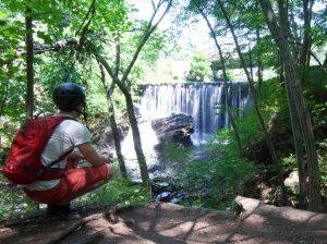
- Long flat section that crosses under Rt. 6 and a short tunnel under Pucker St with brief stretches along the Hop River
- Hop River Rd — 1.34 miles
- Parking: Hop River Rd, Coventry, CT
- Popular parking area
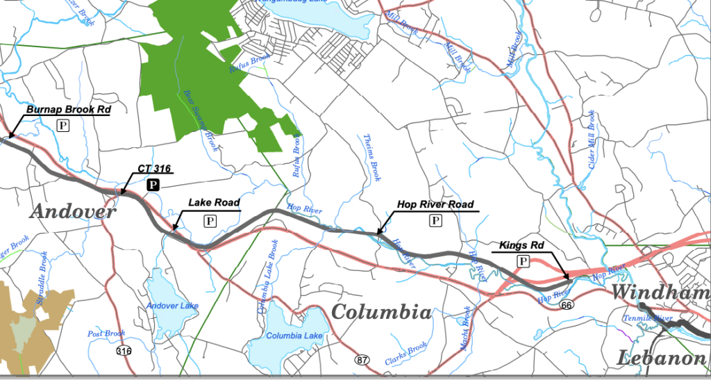
- Parker Bridge Rd — 2.3 miles
- Parking: 61 Parker Bridge Rd Andover, CT
- Crosses a tunnel under Rt. 6 and over Lake Rd (shoulder parking possible, but not recommended)
- Rt. 316 — 1.7 miles
- Parking: Monument Ln Andover, CT
- Covered Bridge Section in Andover, the bridge was put in place in 2012
- Crosses Shoddy Mill Rd and Wales Rd, shoulder parking possible but not recommended
- Burnap Brook Rd — 2.5 miles
- Parking: Burnap Brook Rd, Andover, CT
- Passes through the Andover Sportsman Club where you’ll like here firearms shooting off in the woods
- There’s an old stone whistle marker alongside the trail in this section
- Steele’s Crossing — 2.1 miles
- Parking: 29 Steeles Crossing Rd, Bolton, CT
- Access to Heritage Farm one of Rochambeau’s revolutionary war encampments and Toomey Clark Preserve
- Maintained by Greenway Ambassador Barbara Amodio
- Bolton Notch — 2.3 miles
- Parking: US-6, Bolton, CT
- This section is also a part of the blue blaze Shenipsit Trail
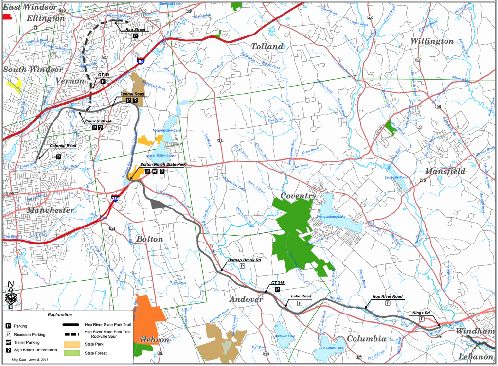
- The trail passes through deep rock cuts and has access to Freja Park, Bolton Notch State Park and Squaw Cave
- Valley Falls — 2 miles
- Parking: 300 Valley Falls Rd, Vernon, CT
- No easy access to the Hop River Trail especially for bikes, but a short hike leads up to it and is a popular section for casual walkers
- Access to Valley Falls trail system on either side of the trail including an overlook
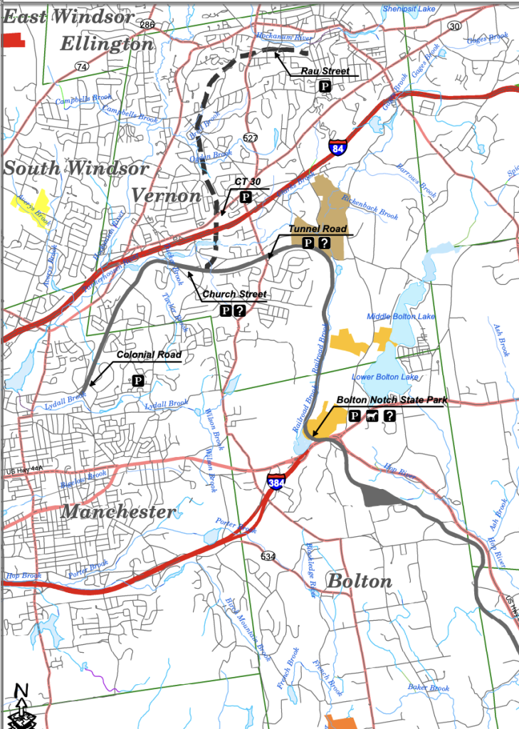
- Church St — 2 miles
- Parking: 51 Church St, Vernon, CT
- Access to the Rockville Spur Trail at the Pheonix St crossing and then a bit down Warren Ave. The spur is 4 miles one way
- Popular trail head with interpretive sign boards, a small pavilion, the remains of a train turntable pit, and more
- Access to Talcotville Ravine Trail and waterfall near Dobson Rd
- Manchester Colony St Terminus
- Parking: 178 Colonial Rd, Manchester, CT
- A short section of old track sits alongside the trail here
- Air Line Junction to Kings Rd — 1 mile
Coming soon!
{{locationDetails}}