Site logo
    • Explore
      • Blue-Blaze Trails
      • Land Trusts
      • State Parks and Forests
      • By Town
    • exploreCT+
      • Membership
      • Shop
      • Events
    • Blog
    • Town Guides
    Sign in or Register
    Listing cover image

    Maples Farm Park

    • Trails
      2 miles
    • Rating
      ★★☆☆☆
    • Address
      Maples Farm Park, 45 Bozrah St, Bozrah, CT 06334, USA
    • Explore
    • Trail Map
    • Reviews 0
    • New Page
    • prev
    • next
    • Bookmark
    • Share
    • Get directions
    • Report
    • prev
    • next
    At A Glance

    Bozrah Town Park

    32 acres in Bozrah, CT

    Parking: Medium lot near 45 Bozrah Rd, Bozrah, CT

    Trail Map      Trails: 2 miles       Rating: ★★☆☆☆

    Maples Farm Park is located behind the Bozrah Famer’s Market and has the distinction of being the only hikeable town park in Bozrah.  The trails here total about two miles and are unblazed but wide and easy to follow.

    Hiking

    At the back left corner of the large field behind the parking lot is the trailhead and kiosk with a map and descriptions of each trail.

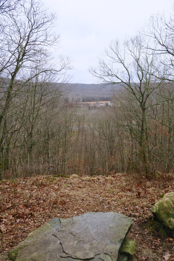
    Bearing left, up the trail from the kiosk, is the start of the Shady Hollow Trail just after Seymour’s Crossing (a short bridge over an unnamed stream).  The trail slowly gains elevation until it reaches the Stonewall Trail which southwest again until reaching the property boundary.  It follows stonewalls and a ridgeline and on a boardwalk over marshy areas.  During the first thaw of January, the trail was muddy and slick throughout.  The trail then merges with the Summit Loop as it curves up to a hill summit.  From there is an easy descent to the choice destination, an overlook, at a steep incline along the northeastern edge.  The view is only a narrow slice through the trees down towards Rt 163, but a well-placed rock offers quiet contemplation.

    While hiking all the trails only took about an hour, they make full use of the property and cover its range of topography and ecology.

    History

    Purchased by the town in 2007, hiking trails were added in 2011.

    Links

    CTMQ – Maples Farm Park (2018)

    Tags
    • ★★☆☆☆
    • 2018
    • Bozrah
    • Explored
    • New London County
    • Overlooks
    Last Updated

    The information shown here is for general reference purposes only. exploreCT.org gives no warranty, expressed or implied, as to the accuracy or reliability of this data. Parking in all areas, whether designated here or not, is at your own risk. exploreCT.org is not responsible for any damage or loss to vehicles or contents. Last updated January 28th, 2018

    Trail Map
    Location
    • Maples Farm Park, 45 Bozrah St, Bozrah, CT 06334, USA

      Get Directions
    Gallery
    Categories
    • Hiking
    • Mountain Biking
    Gallery
  • No comments yet.
  • Add a review

    Leave a Reply · Cancel reply

    You must be logged in to post a comment.

    You May Also Be Interested In

    Spruce Brook Falls

    • ★★★★★
    • 16 miles
    Featured
    FW6F+CW Beacon Falls
    • Quick view
    • Bookmark

    Sparkle Lake Conservation Area

    • Unexplored
    • 0.5 miles
    155 Thomas Rd
    • Quick view
    • Bookmark

    Amos Lake Boat Launch

    • Unexplored
    176 CT-164
    • Quick view
    • Bookmark

    Hi, I’m Matt.

    I’m building ExploreCT to be the guide for all your outdoor adventures. All the trails, views, and waterways this great state has to offer.

    Now get out and explore!

    Monthly Newsletter

    Each month I share site updates or an interesting article in my newsletter. It’s short, sweet, and practical.

    600+ explorers read it, I’d love for you to join.

    Thank you!

    You have successfully joined our subscriber list.

    X-twitter Youtube Envelope Instagram

    Cart

      • Facebook
      • X
      • WhatsApp
      • Telegram
      • LinkedIn
      • Tumblr
      • Reddit
      • VKontakte
      • Mail
      • Copy link
      • Share via...
      • Threads
      • Bluesky