


Major Michael Donnelly Land Preserve
115.5 acres in South Windsor, CT
Parking:
- Main Parking East: Medium sized lot near 1165 Sullivan Ave, South Windsor, CT
- West End: Small lot near 165 West Road, South Windsor, CT
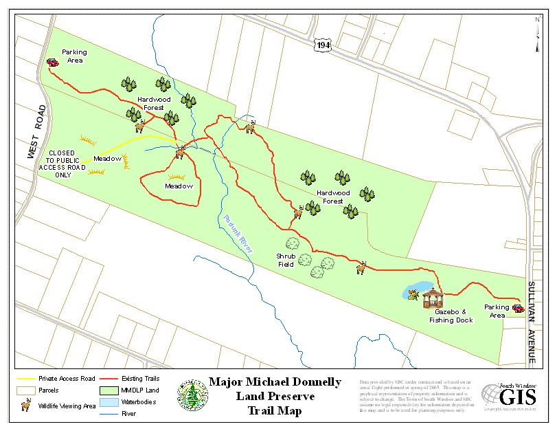
Trail Map Trails: 2.5 miles Rating: ★★★☆☆

Screenshot
I just happened to visit not long after the 20th anniversary of this park’s dedication and was pleasantly surprised by the elaborate boardwalks, wildlife viewing areas, and mixed habitats. The preserve’s trails are fairly easy walking and despite recent heavy rains there were only a couple muddy spots not covered by boardwalks.
Hiking
The main line trail is 1 mile between parking areas and you can get taking the alternate loops adds about 0.3 miles for roughly 2.5 miles round trip.
Next to the main east side parking area is a large field and picnic area with several picnic tables and a monarch way station. A gravel path leads down to the gazebo and a dilapidated fishing dock. A short bridge crosses the north end of an unnamed marshy pond off the Podunck River.
A wide mowed path heads west through tall grass passing a elevated platform for viewing marsh wildlife. There are several short boardwalks that go above the wetter areas of the trail. A long section of boardwalk forks the trail into its first loop. The left (straight) fork continues along the main line of trail and the right fork eventually reaches a heavily wooded forest. The trail has a wildlife blind along this stretch before crossing and recrossing the Podunk River. There also appears to be a connection towards the Dairy Queen off Sullivan Ave.
Returning to the main line you can continue out heading uphill to the east parking area, loop around a small meadow, or just walk the access road for the heck of it. Return to the parking area taking the main line back.
History:
From the town’s brochure:
“On June 26, 2000, 74.9 acres was purchased from John Mitchell for the sum of $750,000 utilizing both the State of Connecticut Open Space and Watershed Acquisition Grant and the Town Open Space Referendum Funding. On December 19, 2001, an additional 40.6 acres was added to the north of the property as part of the open space component of the Strawberry Fields Development… The property was formally dedicated and a sign marking the property entrance off Sullivan Avenue was unveiled on Veterans’ Day, November 11, 2003.”
Links:
- CTMQ – Major Michael Donnely Land Preserve (2017)
The information shown here is for general reference purposes only. exploreCT.org gives no warranty, expressed or implied, as to the accuracy or reliability of this data. Parking in all areas, whether designated here or not, is at your own risk. exploreCT.org is not responsible for any damage or loss to vehicles or contents.
Last updated December 17th, 2023
Visited 795 times, 1 Visits today


