


Rock Spring Preserve
450 acres in Scotland, CT
Parking: Small pull off near 286 Pudding Hill Rd Scotland, CT
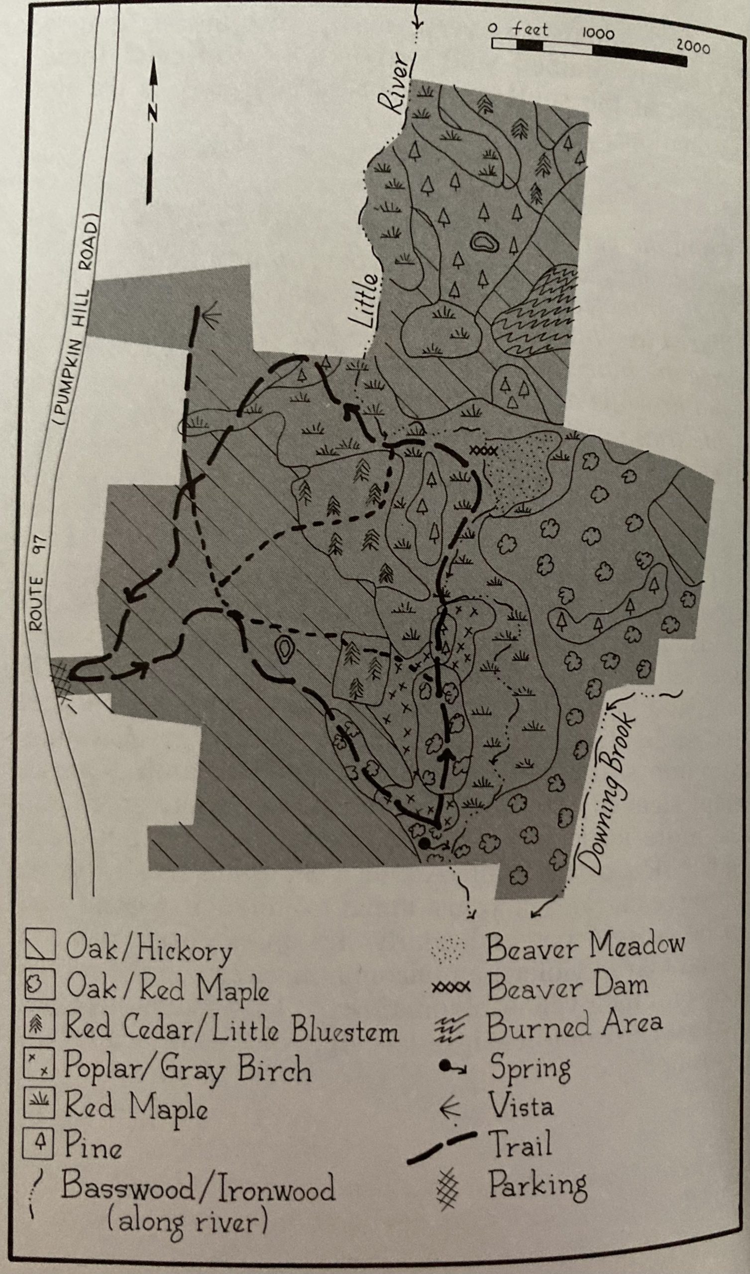
Trail Map Trails: 3 miles Rating: ★★★☆☆

Rock Spring is named for an “Indian Spring” located in the southern section of the property. The trailhead is a small dirt section on the shoulder of Rt. 97. A large new sign was installed around 2015, but the parking can still be easy to miss. Set back just into the woods a small kiosk with maps, some historical information, a logbook, and usually sports a few items lost on the trails. The logbook is an entertaining read and shows how popular even a small trail like this can be.
Every time I have hiked Rock Springs I do the perimeter loop (on the map above), which seems to be the least traveled but hits all the highlights of the property and totals a bit over three miles roundtrip.
Hiking
The trails for the outer loop head eastward on either side of the kiosk. A new hand painted rough trail map sign was added next the kiosk and directional signs point to highlights at trail junctions in early 2019.
The main option heads downhill into heavy forest of oak and hickory in the Little River Valley. After 0.36 miles it reaches a junction which connects the old farm wagon paths that criss-cross the property. The outer loop can be taken by turning right at the junction. You’ll soon pass a kettlehole often filled with water year round on your left and a bit later enter what was once and open field on the farm past a massive old oak (which fell sometime around 2018).
The main stop is the namesake spring also known as ‘Old Indian Spring’. The spring is covered by a small stone column that keeps the protects the main source. A small engraved block built into the column reads ‘Old Bar I Indian Spring‘. If you watch the sand near the column carefully you can see it bubbling up as it drains wide and shallow away from the trail. The narrow ridges that lead to and away from the spring are eskers formed by glacial deposits and erosion. Their sandy soils stunt most kinds of trees except for pitch pine which can thrive on it.
Continuing on the perimeter loop, coming down off the esker you’ll reach the Little River where a large stone bench was added in 2010 dedicated as ‘Mike’s Bench’ a memorial for a local teen. The loop from here is often very overgrown and requires occasional careful footing along the river. You can backtrack a bit to one of the interior trails or push through to some of the properties more interesting hiking.
The northern half of the loop is the most wild. It is frequently overgrown and infrequently blazed has been thankfully reblazed. But, there are high bluffs along the river, secluded fishing spots, and scrambles over glacial till. Note: Occasionally in the spring the water can get high enough to make a stretch impassable. If you’re looking for something beyond a casual walk this part is for you.
In the homestretch back to the parking lot you’ll recross the main wagon path, take the the yellow blazed trail left to an overlook vista of the Little River Valley. The trail climbs a ridge to a set of cliffs with a nice but obstructed view east across the valley. A large stone bench is built with dedications on the back to the Shoemakers who donated the property. There is an 0.5 mile unblazed path leading up to Rt. 97 and a short road walk back to the parking area or retrace your steps back to the outer loop and the parking (about 0.75 miles).
The inner ‘wagon paths’ are generally wider and easier walking, largely serving as more popular shortcuts between the major highlights and back to the parking area.
History:
The property is former farmland.
From the Nature Conservancy site, “David and Vanda Shoemaker donated land for this preserve, which was later augmented by a purchase from a neighbor.”
Links:
- Peter Marteka – Pick Your Trail When Hiking Rock Spring Preserve (2008)
- Peter Marteka – Wildlife Trail Offers 3 Miles of Peace and Beauty (2000)
- Janet Lopes – Rock Spring Preserve: A River Runs Through It (2015 archive link)
- Country Walks in Connecticut: A Guide to The Nature Conservancy Preserves, by Susan D. Cooley, Appalachian Mountain Club Books and the Nature Conservancy, 1989, pp. 117–125.
The information shown here is for general reference purposes only. exploreCT.org gives no warranty, expressed or implied, as to the accuracy or reliability of this data. Parking in all areas, whether designated here or not, is at your own risk.exploreCT.org is not responsible for any damage or loss to vehicles or contents.
Last updated December 4th, 2023
Visited 4741 times, 2 Visits today


