
Down the Connecticut River
ExploreCT Newsletter – The Connecticut River
TL:DR – I paddled 71 miles from the Massachusetts border to Long Island Sound.
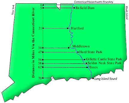
I set out from an Enfield boat launch at around 7:30AM in my Oru Kayak with camping gear, a gallon of water, a loaf of bread I baked, and other foodstuffs. The river was empty and quiet as I paddled upstream to be close to the Massachusetts border.
I should tell you now that the idea for this trip had been rolling around in my head since last fall. In “preparation” I had done a few half-hearted paddles around Mansfield Hollow and down the Willimantic River amounting to a couple miles each time. I planned out a rough trip in the weeks leading up to my vacation. Mind you, all legitimate river campsites are about halfway down the river or more. This meant that my first day was a marathon+ paddle (32ish miles) from the Mass border to River Highlands State Park.
The day was cloudy and the forecast called for rain and thunderstorms starting around 4PM. The first miles of the trip were beautiful. I first passed the Enfield dam and the shallow waters where Adriaen Block turned around upon first exploration of the river in 1614. Calm morning waters were clear enough to see fish darting away from the kayak and I saw my first bald eagle fly over the river. Herons and egrets watched as my kayak passed their fishing spot. The river felt remote and I saw no other boats or people.
The river is shallow north of Hartford and is not subject to the tides that affect the southern portions. I skimmed several sandbars and learned to read which way the water was flowing to navigate them better.
About 4.5 hours in I caught my first glimpse of the Hartford skyline and passed a couple who were relaxing riverside near the old railroad trestle. Surprised to see me, they gave a wary wave. Despite being one of the major cities along the river, there isn’t much as much development as you might think, just a couple parks and the electric plant near the Hartford Jetty. As I passed under the Rt. 2 bridge I saw the East Hartford Police Dive unit parked along the bank. One officer was getting into gear and I watched the bubbles from another diver as I paddled past. Sure I wanted to know what they were diving for, but not as much as didn’t want to get involved.
At this point 20 miles in, just south of Hartford, I had already paddled at least 7x further than I had ever gone before. And, I still had 12 more miles to go. These miles are through the winding undeveloped bends, the “elegant meanders” of the river as it passes through Wethersfield and Glastonbury. It had started to drizzle and a racing shell passed me easily clipping through the water at three times my speed. The hot spots on my hands were getting worse so I had to adjust my grip on the paddle. I really started to question whether I should just pull out at the next public dock I passed. My mood was at a low and I was questioning the whole trip. But, I decided to paddle at least to the next dock I saw and when I got there the next beyond that.
I entered the bends of the river and trees were dense along the banks. The only human elements were the occasional gunshots from farmland on either side of the river and eventually two jet skiers racing upriver. While this stretch was beautiful it’s also the time I ran into, to be polite, brown water. On August 22nd South Hadley, MA had a pump failure that allowed 284,193 gallons of untreated sewage into the river. This was days before my trip and “authorities” assured everyone that the river would clear it easily. My rough calculations (read – could be wrong): at an average flow rate of 18,400 ft³/s the river moves 8.25 million gallons per minute. Which means the spill was .03% of its average volume and it could in theory move all that waste quickly. In practice however, not all the water on the river moves at the same rate. There were several stretches along curved banks and in slow wide areas that had not cleared the waste water. Unfortunately, there was nothing to be done other than paddle around it as best I could.
Somewhat unbelievably miles and hours and rain showers pass. I crossed the historic Rocky Hill-Glastonbury Ferry and realized that I’m within sight of of River Highlands State Park, my camp for the night. A man in a bright red jacket was walking along the beach as I ran my boat onto the shore. The rain had picked up again so I pulled my boat under a tree to let it pass. I stretched after hours in the boat and pulled on my raincoat. A peal of thunder brought the guy back in my direction so we stopped to chat. He said he’d been watching a group of fish move upstream but hadn’t expected thunder so he rushed off. After a couple minutes I decide that this rain wasn’t going to stop like the others and paddled the few hundred feet down shore to the actual camp. The rain only came down harder as I dragged my boat into the treeline and got out my gear.
Everything was wet by the time I got my tent set up except my sleeping bag and food. I remembered to flip over my kayak and, like a drowned rat, climbed into the tent. After being stuck in a kayak for the previous nine hours I was now stuck in a tent. I broke into my loaf of bread and tried to dry my clothes and pass the time until dark. The rain continued through the night but let up in the early morning.
I got out of my tent around six and put on my wet clothes from the previous day. The sun was already pretty bright and I had another long day of paddling ahead so I wasted no time in packing up.
I was able to cram all my wet and muddy gear into a garbage bag and stuffed it into the back of my kayak. I set off soon after 7 while the river was flat and slow. Two bends downriver and about four miles later I reentered civilization as I hit Middletown. The Arrigoni Bridge was bustling and I paused under it to appreciate that I was officially more than halfway through my trip. The river heads almost directly east for about five miles below Middletown. I made it past Dart Island where a man had beached his boat and was fishing. He gave me a hearty hello as I passed. Then it was on to Hurd State Park. Here the wind picked up and I found myself fighting an onslaught of wind, small waves, and slow water.
It was only about three more miles to Haddam Meadows State Park, but I had lost most of my strength in the previous stretch fighting wind and choppy water. The last mile was grueling. I would stop to rest and then psych myself up to push out five or ten paddles, then rest again, and repeat.
Finally reaching the Meadows, I pulled the kayak out at the boat launch and sat down in the shade. I recharged as I watched boats and jet skis unload into the river one after the other. I realized that I had eaten that night’s dinner just to get back to baseline and somehow forgot to pack the next days breakfast as well. I was also down to a quarter gallon of water to boot.
I still had over seven miles to paddle to my second camp and another 14 miles the next morning. Given the struggle I had gone through in the last stretch just to reach Haddam Meadows I was worried that any adverse conditions might sap whatever strength and endurance I had so I made the decision to pull out the next morning.
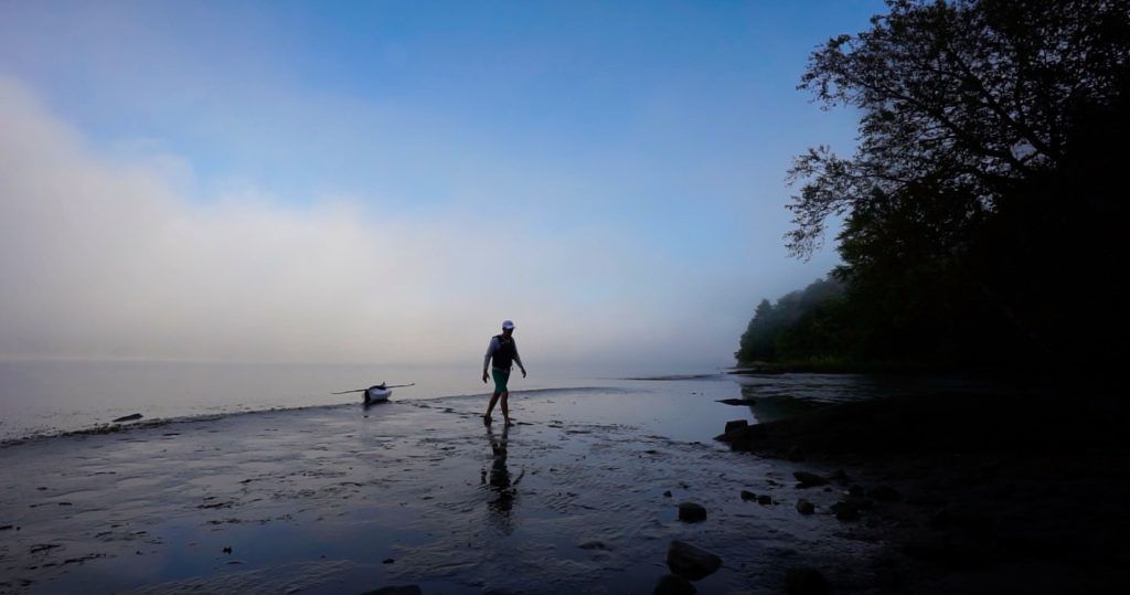
Thankfully, the last seven miles were smooth as I passed Eagle Landing, the Goodspeed Opera House, and a dead fawn on the shores of Rich Island. I had reserved a site at Quarry Knob on Selden Neck, but confused myself and ended up stopping at Hogback Camp. It was a happy accident as the small bluff has a much better view of the river. I was able to dry my gear in the sun as the afternoon faded. I watched as a hummingbird fed on flowers, gold finches flitted in and out of a nearby tree, and osprey swooped to catch fish out of the river. I setup my tent for the best possible sunset view and ate the last of my food, packets of peanut butter and jelly from an MRE. There was also a packet of Skittles, but I couldn’t stand to eat more than a few. The sound of passing boat engines faded soon after sunset and after a failed attempt at a fire with wet wood I went to sleep early.
I pulled out from Gillette Castle the next morning and returned the following Tuesday to complete the river. I checked the tides and picked what I thought was the most favorable timing. I left before sun-up and felt like I was fighting the choppy water for the first few miles. A man and his dog were wandering among the grass in the marshy peninsula north of Essex village. It was low tide and the dog came bounding out to greet me. Not realizing how shallow I was the dog would have easily jumped in my boat had the man not called him back. I soon passed Nott Island and Ferry Marsh and turned the bend to catch my first glimpse of Lynde Point lighthouse through the I-95 bridge pylons. The last three miles were slow going in the wide flat waters at the mouth of the river. This area is unique among major rivers in that there is no major port city at its mouth. Instead we have ever shifting sandbars and “wetlands of international importance” according to the Rasmar Convention on Wetlands.
The final 3,000 feet of my 72 mile journey was from Lynde Point down the Saybrook channel to Old Saybrook Light, my official endpoint. About halfway in I realized the current had caught me and I was going to quickly pass it. I got my camera out for the final shots of my movie and a photo to send to friends and family. There was no time for celebration or even rest as every second meant I was being swiftly carried further out into Long Island Sound.
Next came perhaps the most difficult part of the trip. Not the long 30+ miles of the first day, not the soaking wet first night, or the hungry second night. The time which should have been exuberant. A 2,000ft paddle back up the channel that was a full out sprint. I was leaned forward in my seat to get the longest possible paddle stroke while pulling strong. I maintained that tempo for what seemed like ages fighting my way against the current until reaching the shallow waters off the beach and flopping onto the sand to catch my breath.
As I paddled the 12 miles back to the Gillette Castle boat launch I reflected on the trip. It had been surprising, tiring, and a story I’ll tell for years to come. Moments of peace, moments of struggle, moments of going with the flow, and moments of pushing against it. Here’s to the next big trip!