Site logo
    • Explore
      • Blue-Blaze Trails
      • Land Trusts
      • State Parks and Forests
      • By Town
    • exploreCT+
      • Membership
      • Shop
      • Events
    • Blog
    • Town Guides
    Sign in or Register
    Listing cover image

    Blackledge Falls

    • Trails
      2 miles
    • Rating
      ★★★☆☆
    • Address
      Blackledge Falls, 3874 Hebron Ave, Glastonbury, CT 06033, USA
    • Explore
    • Trail Map
    • Reviews 0
    • New Page
    • prev
    • next
    • Bookmark
    • Share
    • Get directions
    • Report
    • prev
    • next
    At A Glance

    Glastonbury Town Park

    80 acres in Glastonbury, CT

    Parking: Medium sized lot near 3817 CT-94, Glastonbury, CT

    Trail Map           Trails: 2 miles      Rating: ★★★☆☆

    Trails at Blackledge Falls are short but the waterfall makes it a popular draw in the area and there are options for extended hikes.

    Hiking

    Trails within the park are fairly short but are freshly (and a bit over)blazed in 2023.

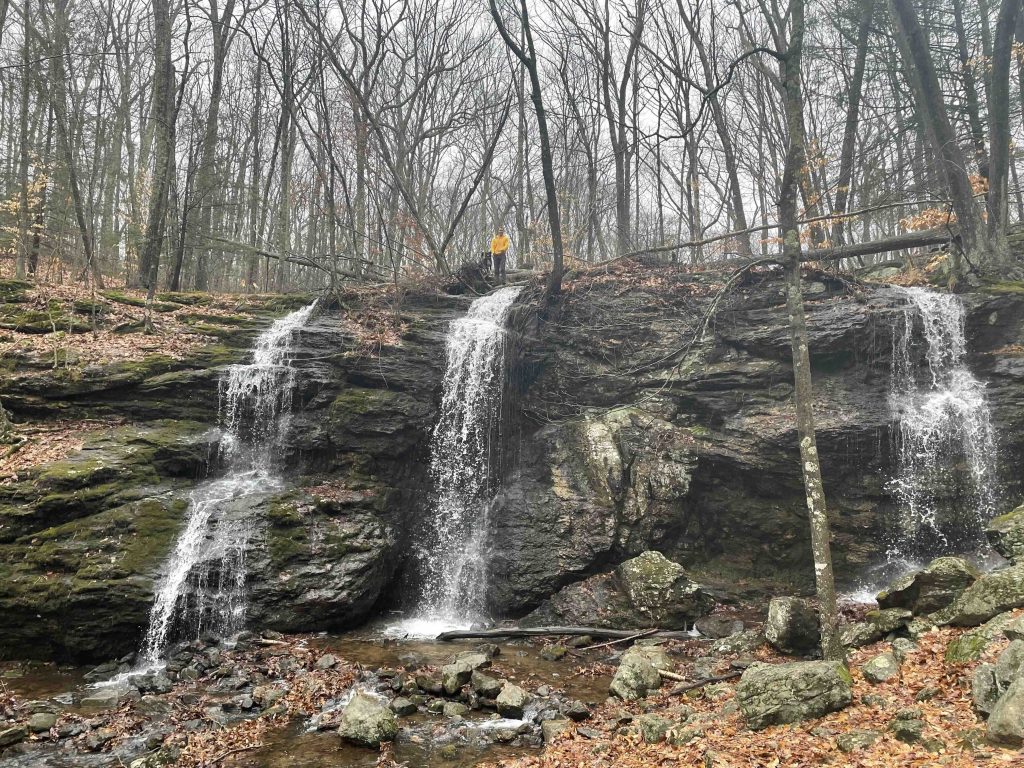
    They start from either the right or left side of the parking lot.  The trail off the left side of the parking area takes you more directly towards the waterfall and rock hops two small streams before a short uphill to the falls. Many spots are rocky, wet, or both. After crossing another stream the trail descends steeply into a bowl shaped hollow where the falls drop 20+ feet in the main section and can split into as many as three distinct drops depending on flow.  It is certainly one of the unique waterfalls in the state though can slow to a trickle in summer droughts.

    Trails off the right side of the parking area lead down to the Blackledge River and the remains of the dam that was taken out in 2018.  The former pond is now regrowing into a regular riparian habitat.  There used to be a rock hop crossing here to mountain bikes trails on the other side of the river, but the river has been two deep to use them on my last couple visits. Back on the blazed trail you cross a small footbridge working up a blue blazed loop through rocky forest and around to the waterfall.

    The backside of the loop connects to Gay City State Park for extended hike options.

    History

    Preserved in 1990 when Thomas and Joan Kemble sold the falls property to the town for $700,000.  In 2006, the Kembles sold the town an additional 7.49 acres adjacent to the falls.

    The dam at the edge of the park was removed in 2018.  There is now a wide clearing down to the river and when it is low enough stepping stones to cross to the trail on the other side.  Photos below of the pond in 2017 before and in 2018 after the dam removal:


    Links

    Peter Marteka – The Blackledge River Is Flowing Naturally Again For The First Time Since The 19th Century (2018)

    CTMQ – Blackledge Falls Preserve (2014)

    Peter Marteka – Family Offers Land To Town (2006)

    New England Waterfalls – Blackledge Falls

    Tags
    • ★★★☆☆
    • 2017
    • 2018
    • 2023
    • Explored
    • Glastonbury
    • Hartford County
    • Peter Marteka
    • Waterfalls
    Last Updated

    The information shown here is for general reference purposes only. exploreCT.org gives no warranty, expressed or implied, as to the accuracy or reliability of this data. Parking in all areas, whether designated here or not, is at your own risk. exploreCT.org is not responsible for any damage or loss to vehicles or contents. Last updated January 23rd, 2023

    Trail Map
    Location
    • Blackledge Falls, 3874 Hebron Ave, Glastonbury, CT 06033, USA

      Get Directions
    Gallery
    Video
    Categories
    • Hiking
    Gallery
  • No comments yet.
  • Add a review

    Leave a Reply · Cancel reply

    Your email address will not be published. Required fields are marked *

    Overall Rating

    You May Also Be Interested In

    Spruce Brook Falls

    • ★★★★★
    • 16 miles
    Featured
    FW6F+CW Beacon Falls
    • Quick view
    • Bookmark

    Thach Preserve

    • ★★☆☆☆
    • 1 miles
    123 Brush Hill Rd
    • Quick view
    • Bookmark

    Mendell's Folly

    • ★★★★☆
    • 3.8 miles
    390 Beacon Rd
    • Quick view
    • Bookmark

    Hi, I’m Matt.

    I’m building ExploreCT to be the guide for all your outdoor adventures. All the trails, views, and waterways this great state has to offer.

    Now get out and explore!

    Monthly Newsletter

    Each month I share site updates or an interesting article in my newsletter. It’s short, sweet, and practical.

    600+ explorers read it, I’d love for you to join.

    Thank you!

    You have successfully joined our subscriber list.

    X-twitter Youtube Envelope Instagram

    Cart

      • Facebook
      • X
      • WhatsApp
      • Telegram
      • LinkedIn
      • Tumblr
      • Reddit
      • VKontakte
      • Mail
      • Copy link
      • Share via...
      • Threads
      • Bluesky