Tolland

Hike Tolland, CT

If you’re looking for the best hiking trails in Tolland this is the complete guide to all the long trails, disc golf, and history it has to offer.

Links

Hiking

Town Parks

  • Auperin Conservation Area –★– <1 mile — A short side trail that connects to Weigold and the Tobiassen Forest
  • Becker Conservation Area –★★– 1 mile — The current terminus of the Willimantic River Trail on this short loop
  • Campbell’s Peaceful Valley –★– 2.2 miles — A great rocky overlook with plenty of trails to explore and a connection to Stoppleworth
  • Crandall Park –★★★– 5 miles — Popular town park with hiking and mountain biking trails, a beach, courts, fields, pavilions, and more
  • Cross Farms –★★– 1 mile — There is an seldom used hiking trail here though half has been taken over by the disc golf course
  • Crystal Peat Conservation Area — Unexplored
  • Heron Cove –★★– <1 mile — Mainly a boat launch into the Willimantic River, but there is a short loop trail that follows the banks
  • King Riverside –★★– 1.2 miles — Part of the Willimantic River hiking trail with the remains of Peck’s Mill and the the District IV schoolhouse
  • Knofla Conservation Area –★★– 2.9 miles — Forested trails lead down to Knofla’s Pond, a bog view, and hilly loops
  • Luce Conservation Area –★★– 1 mile — Tiny cascades on Charter Brook, a rocky spine covered in young pines, and a flooded stonewall
  • Nedweid Conservation Area –★– 1 mile — Seldom used section of the Willimantic River hiking trail connects to King Riverside
  • Palmer Kendall Mountain –★★★– 1.5 miles — A ridge overlook, the “knob”, and a rock jumble they call a “quarry”
  • Parciak Conservation Area –★★– 2.8 miles — A “meteor” and a quartz boulder highlight the trails here
  • Paulk Hill Conservation Area –★★– 5 miles – Mountain bike specific trails that connect to Crandall Park
  • River Park –★★– 1 mile — Oddly there are no river views from the park, but trails connect to the Becker CA which do
  • Schindler/Schmidt Conservation Area –★★– 3.8 miles — Mostly easy walking on old roads through rocky terrain
  • Shafran Conservation Area –★★– 1.4 miles — One of the most peaceful places with pines, ferns, and clear streams
  • Stoppleworth Conservation Area –★– 1 mile — An old cellar hole, birch lined paths, and a connection to Campbell’s Peaceful Valley
  • Weigold Conservation Area –★– <1 mile — A short trail that connects to Auperin and the Tobiassen Forest

Land Trust – Joshua’s Trust

  • Madeline Regan Preserve –★★– 1 mile — A figure eight hiking loop preserving a section of the Old Connecticut Path and a dramatic esker
  • Tobiassen Forest –★★– 2 miles — A short wooded loop with some grand old trees

State Parks / Forest

Blue Blaze – Shenipsit Trail

  • Shenipsit Lake –★★– 1 mile — The Connecticut Water Co. trolley trail, flat easy walking with a view or two of the lake

The Rest

  • Benton Homestead –★– <1 mile — A short unmaintained loop next to the roar of I-84, the homestead is a museum
  • Willimantic River Trail — Tolland is the current northern terminus of this long trail

Disc Golf

Boating/Fishing

Archery

Now get out and hike Tolland, CT!

Knofla Conservation Area

★★☆☆☆

41.90484,-72.38196

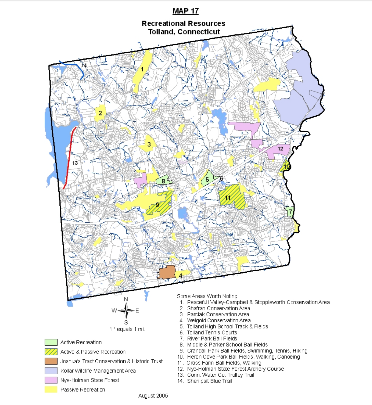
Knofla Conservation Area Tolland Conservation Area 138.1 acres in Tolland, CT Parking: Small lot at 148 Bakos Road Tolland, CT Trail Map            Trails:…

Heron Cove

★★☆☆☆

41.876902, -72.310465

Heron Cove Tolland Town Park 35 acres in Tolland, CT Parking: Large lot at 125 South River Road, Tolland, CT Trail Map        Trails: Less than…

Palmer Kendall Mountain

★★☆☆☆

145 Cook Rd, Tolland, CT, USA

Palmer Kendall Mountain Conservation Area Tolland Conservation Area 74 acres in Tolland, CT Parking: Small pull off near 145 Cook Rd Tolland, CT Trail Map       …

Parciak Conservation Area

★★☆☆☆

41.88740,-72.38012

Parciak Conservation Area Tolland Conservation Area 60 acres in Tolland, CT Parking: Shoulder parking near 207 Bald Hill Rd, Tolland, CT Trail Map           Trails:…

Nedweid Conservtion Area

★★☆☆☆

41.849579, -72.310807

Nedwied Conservation Area Tolland Conservation Area 15 acres in Tolland, CT Parking: Shoulder parking between 106 and 116 Fox Ridge Lane Tolland, CT Trail Map       …

King Riverside

★★☆☆☆

41.83767,-72.31231

King Riverside Conservation Area Tolland Town Park 30 acres public access, 173 total in Tolland, CT Parking: Medium sized lot near 15 Dimock Road Tolland, CT Trail…

Tobiassen Forest

★★☆☆☆

41.837496, -72.368407

Doris and Al Tobiassen Memorial Forest Joshua’s Trust Property 84 acres in Tolland, CT Parking: At the cul-de-sac near 33 I/010, Tolland, CT Trail Map     …

Shenipsit Lake

★★☆☆☆

41.881941, -72.422886

Shenipsit Trail – Shenipsit Lake Connecticut Blue Blaze Trail in Tolland, CT Parking: Shoulder parking near 15 Tolland Stage Rd, Tolland, CT Trail Map        …

Crystal Peat Conservation Area

★★☆☆☆

41.913372,-72.356865

Crystal Peat Conservation Area Tolland Town Park 30.5 acres in Tolland, CT Parking: Small pull-off near 167 Cook Rd Tolland, CT Trail Map.      Trails: 1 mile…

Kollar Wildlife Management Area

★★☆☆☆

41.907256, -72.299180

Kollar Wildlife Management Area Connecticut Wildlife Management Area 900+ acres in Tolland, CT Parking: Small lot just east of 130 N River Rd Tolland, CT Hunting Map …